(Sample Material) Online Coaching for CAPF (AC): Geography - "World Geography (Part - 4)"
Online Coaching for UPSC Central Armed Police Forces (AC) Written Examination
Geography
World Geography (Part - 4)
Hydrosphere
- The properties of water in its three physical states make it by far the most useful of all compounds.
- Its high specific heat, ability to exist in all three states and capacity for storing or releasing latent heat with changes of state give it immense influence on atmospheric processes.
Oceans and Seas
- The oceans comprise more than 70% of the earth’s surface.
- They exert a great influence upon the global and regional climates in a variety of ways.
- They act as ‘savings bank’ for solar energy, storing the excess during summers and daytime and repaying back during nights and winters.
- Because of their surface area, the seas receive almost 71 per cent of all incoming sun energy.
- The amount of the sun’s energy absorbed by a sea surface depends on the way the sun’s rays meet the surface.
- When the rays are vertical all of the sun’s energy is absorbed: when they are oblique most of the sun’s energy is reflected.
- The energy absorbed by the seas is confined to the surface layers, which are warmed by it, and which become less dense (lighter) as a result.
- The heated surface layers remain above the colder and denser layers beneath.
- The seas are much warmer in equatorial latitudes than in polar latitudes.
- They also help to modify the distribution of temperature along the coastal areas.
- Oceans are the primary source of moisture in the atmosphere and much of the rain over the continents.
- They help sustain the ‘hydrological cycle’.
- The sea, as a biological environment, is the easiest available and an inexhaustible source of food and other products of value to man.
- Of all the marine resources, fish is the most abundant and important, constituting about 90 per cent of all biotic resources extracted from the oceans.
- Oceans are the repository of a large number of useful metallic and non-metallic minerals such as petroleum, gas, common salt, manganese, gold, diamonds, tin and iron among others.
- Bromine and Sulphur, which are otherwise rare on land, can be abundantly sourced from oceans.
- Polymetallic nodules of copper, magnesium and cobalt are also found on the sea floor.
- The energy resources of oceans come in various forms: the conventional forms like oil and natural gas and the non-conventional types.
- There are over 90 different possible ways to obtain energy from oceans, important among them being the energy derived from waves, wind and tides.
- Relief: Ocean basins are in many ways similar to the land surface.
- Just like on land, there are mountains, plains, plateaus and canyons.
- A section drawn across an ocean illustrates the typical submarine relief features:
Salinity and Temperature
Temperature of Ocean Waters
- It is an important factor in controlling the movements of large masses of ocean water and their characteristics.
- The type and distribution of marine fauna and flora also depend largely on the temperature of the water.
- With respect to temperature there are three layer in the oceans from surface to the bottom in the tropics:
- Epilimlion layer: It represents the top-layer of warm oceanic water and is 500m thick with temperature ranging between 20 and 25°C.
- Thermocline layer: It represents vertical zone of oceanic water below the first layer and is charactized by rapid rate of decrease of temperature with increasing depth.
- Hypolimlion layer: It is very cold and extends upto the deep ocean floor.
- The temperature decreases according to the increasing depth of the ocean.
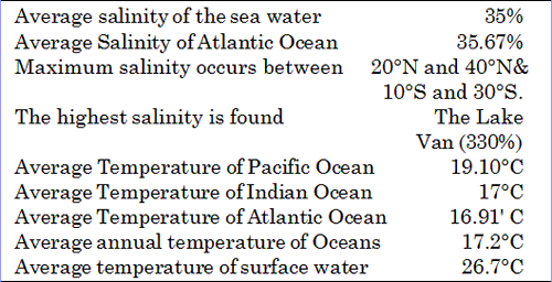
- On an average, the temperature of surface water of the oceans is 26.7°C and the temperature gradually decreases from equator towards the poles.
- The rate of decrease of temperature with increasing latitudes is generally 0.5°F per latitude.
- The average temperatures become 22°C at 20° latitude, 14°C at 40° latitude and) C near the poles.
- The oceans in the northern hemisphere record relatively higher average temperature than in the southern hemisphere.
- The average annual temperatures for the northern and southern hemisphers are 19.4°C and 16.1°C respectively.
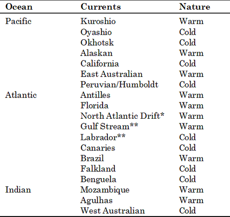
* It keeps the ports like, Murmansk in Russia, situated at high latitudes
ice-free throughout the year.
** The confluence of these two currents produces the famous Newfoundland fogs.
The area is one of the most important fishing grounds in the world.
-
The trade winds blow so continuously and with such regular strength that they drag surface water from Africa and pile it up in the Caribbean and the Gulf of Mexico, causing the level of the water in the latter to rise. This pile up of warm water is one-of the causes of the Gulf Stream.
- Similarly, the waters of the Gulf Stream are dragged along by the westerly winds towards the coasts of Britain and Europe.
- The main effect of prevailing winds on ocean current flow occurs in an east-west direction.
- The main effect of temperature differences occurs in north-south flows.
- Another effect of prevailing winds on ocean current flow occurs along some leeward coasts, i.e. coasts where the winds are offshore. This can be seen along the west coast of Africa.
- As the winds blow water away from the coast, sub-surface cold water wells up offshore which forms the cold currents known as the Canaries and Benguela currents.
- Another point to remember is that the Coriolis force caused by the rotation of the earth results in ocean currents following curving paths.
- Ocean currents influence the climate of bordering coastal regions.
- They affect temperature, humidity and precipitation.
- Cold currents bring planktons from the cold polar and sub-polar zones and thus increase the food supply for fish.
- As a result, fish thrive in large numbers in these areas.
Tides and Waves
Tides
- The seawater rises regularly twice a day at constant intervals.
- This periodic phenomenon of alternate rise and fall in the sea levels is known as tide, and is produced due to gravitational interaction of Earth, moon and sun.
- Moon exerts the strongest influence on tides because of its closeness to Earth.
- On the full moon and the new moon, tides are the highest (Spring Tides) while on the 1st and 3rd quarters, tides are lower than the usual (Neap Tides).
Friendly side of the tides
- Tides generally help in making some of the rivers navigable for ocean-going vessels.
- London and Calcutta have become important ports owing to the tidal nature of the mouths of Thames and Hooghly, respectively.
- Tides also clear away the sediments brought by rivers and thus retard the formation of deltas and help in cleaning the coastal regions.
- The tidal force may also be used as a source for generating electricity as is being done already in La Rance, France (a pioneer in this field), Japan and now in India (in the Gulfs of Cambay and Kutch).
Tidal Facts
- Highest tidal amplitude and range-Bay of Fundy; Highest Tides recorded in India at Okha, Gujarat.
- It takes 24 hours and 50 minutes for the rotating Earth to bring the same meridian vertically below the moon every day. Hence, tides occur at regular intervals of 12 hours and 25 minutes.
- Generally, tides occur twice a day. But Southampton, along the southern coast of England, experiences tides 4 times a day.
Waves
- Waves are the oscillatory movements in water mainly produced by winds, manifested by an alternate rise and fall of the sea surface.
- Besides wind-produced waves, other types of waves include catastrophic waves (sudden, violent and temporary), storm waves and seiches (stationary waves).
- The waves are an important agent of erosion in the coastal regions where they sculpt and carve out various landforms like caves, bays and gulfs, capes and cliffs.
Tsunami
Tsunami is a Japanese word with the English translation, “harbor wave.” Represented by two characters, the first character, “tsu,” means harbor, while the later character, nami,” means “wave.” In the past, tsunamis were sometimes referred to as “tidal waves” by the general public, and as “seismic sea waves” by the scientific community.
A tsunami is a series of waves created when a body of water, such as an ocean, is rapidly displaced. Earthquakes, mass movements above or below water, volcanic eruptions and other underwater explosions, landslides, underwater earthquakes. large meteoroid or asteroid impacts and testing with nuclear weapons at sea all have the potential to generate a tsunami. The effects of a tsunami can range from unnoticeable to devastating.
- Waves generated in this manner are called tsunamis or seismic sea waves. They can be quite dangerous.
Ocean Ridge
The Pacific Ocean
- This ocean is the largest of all the water bodies.
- Together with its associated seas, it covers about one-third of the earth’s surface and exceeds the total land arcs of the world in size.
- Its shape is roughly triangular with its apex in the north at the Bering Strait.
- The Pacific is the deepest of all oceans.
- The major portion of the basin has an average depth of about 7,300 metres.
- This vast ocean is dotted with more than 20,000 islands.
- The islands situated close to the continent are continental islands. The islands appearing in the mid-ocean are coral and volcanic in origin.
- The Northern Pacific is the deepest part of the ocean. The average depth of this part ranges between 5,000-6,000 metres.
- Aleutian, Kurile, Japan and Bonin are some well-known trenches of this part.
- There are also a large number of seamounts, guyots and parallel, and arcuate island chains in the central part.
- The south-west portion of the Pacific is marked by a variety of islands, marginal seas, continental shelf and submarine trenches.
- The Mindanao trench is more than 10,000 metres deep.
- The average depth of this part is about 4,000 metres.
- The south-east Pacific has broad submarine ridges and plateaus.
- This part of the Pacific is conspicuous by the absence of marginal seas.
- The Tonga and Atacama trenches in this part are about 9,000 and 8,000 metres deep, respectively.
The Atlantic Ocean
- It is roughly half the size of the Pacific Ocean and covers about one-sixth of the earth’s total area.
- It resembles the letter ‘S’ in shape.
- The continental shelf occurs all around the Atlantic Ocean, but it varies in width.
- Off the coast of Africa, it is 80-160 kilometres wide but off the coast of north-east America, north-west Europe, it is 250-400 kilometres wide.
- The Atlantic Ocean has numerous marginal seas on both sides, especially in its northern part.
- Most of the marginal seas are located on the shelves.
- The Hudson Bay, the Baltic Sea, and the North Sea are located on the shelves.
- The most striking feature of the Atlantic Ocean is the presence of the mid-Atlantic Ridge.
- It extends from the north to the south paralleling the ‘S’ shape of the ocean itself.
- The ridge is about 14,000 km long and the 4,000 metres high.
- The ridge though under the sea level has many peaks projected out of the deep water above the surface of the ocean.
- These peaks are the islands of the Mid-Atlantic.
- Examples include Pico Island of Azores, Cape Verde Island.
- In addition, there are some coral islands such as Bermunda and Volcanic Islands like. Ascension, Tristan da Cunha, St Helena, Gough and others.
- The Atlantic Ocean lacks in troughs and trenches which are more of a characterstic of the Pacific Ocean.
- North Cayman and Puerto Rico are the two troughs and Romanche and South Sandwich are the two trenches in the Atlantic Ocean.
The Indian Ocean
- The Indian Ocean is smaller than the Atlantic Ocean.
- It can be considered only half an ocean.
- The average depth of the Indian Ocean is 4,000 metres which is comparatively lesser than that of other oceans.
- Marginal seas are also few.
- The floor of the Indian Ocean has fewer irregularities in comparison to the other two oceans.
- Linear deeps are almost absent. The only exception is the Sunda Trench, which lies south of the island of Java and runs parallel to it.
- There are a number of broad submarine ridges on the floor of the Indian Ocean.
- Like the Atlantic Ocean, a prominent submarine ridge runs from Kanya Kumari continuously southward to Antarctica.
- Unlike the Atlantic Ridge, it is wider and does not extend so near the surface.
- It is called the Lakshdweep-Chagos Ridge in the north, the St Paul Ridge in the middle and the Amstredam St Paul Plateau in the south.
- Two minor and parallel ridges run north westward. These are known as the Socotra Chagos Ridge and the Seychelles Ridge.
- Another ridge, known as the South Madagascar Ridge, runs southward from the Madagascar island.
- It widens in the south, where it is called the Prince Edward Crozet Ridge.
- In the Bay of Bengal, another ridge called the Andaman-Nicobar extends from the mouth of the Irrawaddy to the Nicobar Islands.
- The Carlsberg Ridge has been discovered by recent surveys and it divides the Arabian Sea into two parts.
- Most of the islands in the Indian Ocean represent detached parts of the continental blocks.
- The Lakshdweep and Maldive Islands, off the coast of south-western India, represent coral islands.
- The Mauritius and Reunion islands to the east of Madagascar are of volcanic origin.
Coral Reef
- Coral reefs are structures produced by living organisms, found in shallow, tropical marine waters with little or no nutrients in the water.
- High nutrient levels such as that found in runoff from agricultural areas can harm the reef by encouraging the growth of algae.
- In most reefs, the predominant organisms are stony corals, colonial cnidarians that secrete an exoskeleton of calcium carbonate (limestone).
- The accumulation of skeletal material, broken and piled up by wave action and bioeroders, produces a massive calcareous formation that supports the living corals and a great variety of other animal and plant Iife
- Coral reefs can take a variety of forms, defined in following;
- Apron reef - short reef resembling a fringing reef, but more sloped; extending out and downward from a point or peninsular shore.
- Fringing reef - reef that is directly attached to a shore or borders it with an intervening shallow channel or lagoon.
- Barrier reef - reef separated from a mainland or island shore by a deep lagoon.
- Patch reef - an isolated, often circular reef, usually within a lagoon or embayment.
- Ribbon reef - long, narrow, somewhat winding reef, usually associated with an atoll lagoon.
- Table reef - isolated reef, approaching an atoll type, but without a lagoon.
- Atoll reef - a more or less circular or continuous barrier reef extending all the way around a lagoon without a central island.
- Bank Reef - Bank reefs are larger than patch reefs and are linear or semi-circular in outline.
World-wide distribution of reefs
- Coral reefs are estimated to cover 284,300 square kilometres with the Indo-Pacific region (including the Red Sea, Indian Ocean. Southeast Asia and the Pacific) accounting for 91.9% of the total.
- Southeast Asia accounts for 32.3% of that figure, while the Pacific including Australia accounts for 40.8%.
- Atlantic and Caribbean coral reefs only account for 7.6% of the world total.
- Coral reefs are either restricted or absent from along the west coast of the Americas, as well as the west coast of Africa.
- This is primarily due to upwelling and strong cold coastal currents that reduce water temperatures in these areas.
- Corals are also restricted from off the coastline of South Asia from Pakistan to Bangladesh.
- They are also restricted along the coast around north-eastern South America and Bangladesh due to the release of vast quantities of freshwater from the Amazon and Ganges Rivers respectively.
- Famous coral reefs and reef areas of the world include:
- The Great Barrier Reef- largest coral reef system in the world, located in Queensland, Australia;
- The Belize Barrier Reef- second largest in the world, located in Belize, Central America; and
- The Red Sea Coral Reef - located off the coast of Egypt and Saudi Arabia.
- Pulley Ridge - deepest photosynthetic coral reef, located in Florida, USA.
- Many of the numerous reefs are found scattered over the Maldives.