NEW! The Gist (APR-24) | E-BOOKS |
(IGP) GS Paper 1 - India & World Geography - "North America"
Integrated Guidance Programme of General Studies for IAS (Pre)
Subject - India & World Geography
Chapter : North America
North America
North America is surrounded by the Atlantic Ocean in the east, Gulf of Mexico in the south, the Pacific Ocean in the west and the Arctic Ocean in the north. To the north it is separated from the easternmost tip of Siberia by the Bering Strait.
Size : Third largest continent after Asia and Africa.
Important Seas, Bays and Gulfs
| Name | Location and Related Information | Part of Ocean |
| Beaufort Sea | North of Canada. | Arctic Ocean |
| Gulf of Boothia | Between Boothia Peninsula and Baffin Island, North of Canada | Arctic Ocean |
| Baffin Bay | Between Greenland and Baffin Island. | Atlantic Ocean |
| Hudson Bay | North of Canada. | Atlantic Ocean |
| James Bay | North of Canada. | Atlantic Ocean |
| Labrador Sea | East of Labrador, Canada. | Atlantic Ocean |
| Gulf of St. Lawerance | Northest of USA St. Lawrence River drains. | Atlantic Ocean |
| Bay of Fundy | Between New Brunswick and and Nova Scotia. Site of highest tides. | Atlantic Ocean |
For Detail Description, Analysis and More MCQs of the Chapter Buy this Study Notes:

Important Straits:
| Name | Separates | Connects |
| Nares Straits | Greenland and Ellesmere Island | Arctic Ocean and Baffin Bay |
| Davis Strait | Greenland and Baffin Island | Baffin Bay and Labrador Sea. |
| Hudson Strait | Baffin Island and Ungava Peninsula (Qubec) | Hudson Bay and Labrador Sea. |
| Belle Isle Strait | Labrador and New Foundland | Gulf of St. Lawrence and Atlantic Ocean |
| Florida Strait | Florida and Cuba. | Gulf of Mexico and Atlantic Ocean |
| Yucatan Strait | Yucatan Peninsula (NE Mexico) and Cuba | Gulf of Mexico and Atlantic Ocean |
Important Lakes of North America
- Great Bear Lake: Lake of North West Territories through which Arctic Circle pass. At Port Radium valuable deposits of pitchblende exist.
- Great Slave Lake: Lake lies in the North West Territories of Canada. On the shore copper and gold are worked.
- Athabasca Lake: Uranium city lies on the north shore of lake, where pitch-blende is found.
- Reindeer Lake: Water flow north-eastwards to Hudson Bay via the Churchill River.
- Lake Winnipeg: Lake of Manitoba is a remnant of glacial Lake Agassiz Saskat-chewan River drains into the lake. Also the water flows north eastwards and Hudson Bay via Nelson River.
6. Great Lakes (HOMES)
(i) L. Superior (S)
(ii) L. Michigan (M)
(iii) L. Huron (H)
(iv) L. Erie (E)
(v) L. Ontario (O)
Information: Connected to the Atlantic Ocean by the St. Lawrence Seaway, to the Gulf of Mexico via the Illinois water way and the Mississippi River, and to New York through the Hudon River
Important Rivers of North America
Rivers of Canada:
| Important Rivers | Source | Outflow |
| Mackenzie (longest river of Canda) | Head of Finlay River (British Columbia) | Beaufort Sea. |
| Yukon | Junction of Lewes and Pelly Rivers | Bering Sea. |
| Nelson | Head of Bow River (Canada) | Hudson Bay. |
| Saskatchewan | Rocky Mountain | L. Winnipeg |
| Peace (Bennete Dam is located on the Peace river) | Stikine Mountain | Lake Athabaska |
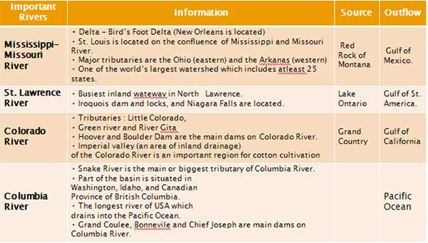
Rivers of USA:
Important Mountains Ranges of North America:
Brook’s Range
- Located in Northern Alaska. Extends in the east-west direction and is a continuation of the Rocky.
The Alaska and Aleutian Ranges
- Terminate in the Aleutian islands, are part of the Pacific Mountain Systems.
- Mount McKinley (6194 m) is the highest peak of North America is in the Alaska Range.
Western Cordillera
They are made up of three almost parallel ranges, running north to south.
(i) Coast Mountains
Mount Logan (6050 m) in the Yukon Territory (Canada) is-the second highest peak of North America.
(ii) (a) Cascade Range
- East of Coast Mountain, running from the North California to Washington.
- Mount Whitney (4418 m) is the highest peak of USA.
(b) Sierra Nevada
- From south of Cascade Range to southern California along the Pacific coast.
(iii) Rocky Mountains
- Lies east of the Cascade range and Sierra Nevada, running from Alaska to Mexico and is over 4000 m.
- It is the easternmost and is the highest range among the western Cordilleras.
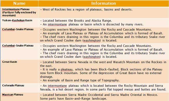
- West of the Rockies lies a region of table-lands, basins, canyons and deserts.
Important Plateaus and Basins
For Detail Description, Analysis and More MCQs of the Chapter Buy this Study Notes: