(Sample Material) Online Coaching for CAPF (AC): Geography - "Indian Geography (Part - 2)"
Online Coaching for UPSC Central Armed Police Forces (AC) Written Examination
Geography
Indian Geography (Part - 2)
Physical Features of India
- Out of the total area of the country, about 10.6% is occupied by mountains, 18.5% by hills, 27.7% by plateaus and 43.2% by the plains.
- India may be divided into four major physiographic regions, viz, 1. The Northern Mountains, 2. The Great Plains, 3. The Peninsular Uplands, and 4. The Indian Coasts and Islands.
I. The Northern Mountains
-
The region extends all along the northern frontier of the country, for about 2500 km, with a varying width of 240 to 320 km and a total area of about 5,00,000 km’.
-
Himalayas represent the youngest and the highest folded mountains of the earth, rising to over 8000m above sea level and consisting of three parallel ranges: (a) Himadri (Greater Himalaya), (b) Himachal (Lesser Himalaya), and (c) the Siwaliks (Outer Himalayas).
-
The Vale of Kashmir, about 135 km long and 40 km broad, is the only large level strip of land in the Himalayas.
-
In the Himalayas snow fields cover about 40,000 sq km of area from Kashmir to Assam.
-
The height of snow line varies between 4000-5800m in the east and 4500-6000m in the west.
-
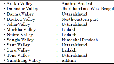
The Himalayas are intersected by numerous valleys like Kashmir valley, the Karewas, the Doon valley, the Kangra and Kullu valley (Himachal Pradesh), Kathmandu valley (Nepal), Bhagirathi valley (near Gangotri) and Mandakini valley (near Kedarnath).
-
The Himalayas may be conveniently divided into following four parallel zones.
- The Tibetan Zone: This is about 40 km wide and consists of fossil bearing marine sediments which are underlain by ‘tertiary granite’.
- The Greater Himalayan Zone: This zone rises abruptly like a wall north of the Lesser Himalayas. It is about 25 km wide with average height above 5000 m.
- The Lesser Himalayan Zone: It is about 80 km wide with average height between 1300 to 5000m. It generally consists of unfossiliferous sediments or metamorphosed crystal-lines, constituting the main nappe zone in the Kashmir, Himachal and Garhwal sections.
- The sub-Himalayan Zone: This is a 8 to 45 km wide zone with average height below 1300 m.
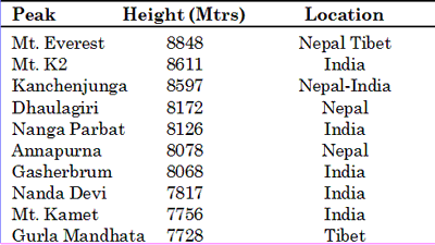
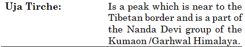
Peaks of India
Valleys and its locations
Divisions of the Himalayas
(a) The sub-Himalaya or Siwaliks
- The range has a total length of about 2400 km from the Indus gorge to the Brahmaputra valley.
- It is known by various local names, i.e. the Jammu hills (Jammu & Kashmir), the Dundwa range (Uttarakhand), the Churia Muria hills (Nepal), the Daffla, Miri, Abor and Mishmi hills (Arunachal Pradesh).
- The gorges of the Tista and the Raidak have jointly formed a 90 km gap in the Siwalik range.
- This is a 8 to 45 km wide zone with average height below 1300 m.
- The Siwalik Range forms the southern part of the zone and the intervening area is generally occupied by the tectonic longitudinal valleys called the Duns, viz., Dehra, Kotah, Path, Kothri, Chumbi and Kyarda.
Peaks and its locations

(b) The Lesser Himalaya or Himachal
- It is about 80 km wide with average height between 1300 to 5000 m.
- It generally consists of unfossiliferous sediments or metamorphosed crystallines, constituting the main nappe zone in the Kashmir, Himachal and Garhwal sections.
- Important ranges include the Dhauladhar, Pirpanjal, Nag Tiba, Mahabharat range and Mussoorie range. The famous hill resorts like Shimla, Chail, Ranikhet, Chakrata, Mussoorie, Nainital, Almora and Darjeeling etc are situated over this range.
- Along the slopes are found a number of small pastures which are called merg in Kashmir (viz. Gulmerg, Sonmerg, Tanmerg) and Bugyal and Payar in Uttarakhand.
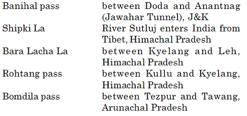
- The best known passes of the Pir Panjal range are the Pir Panjal Pass (3480 m), the Bidil (4270m), Golabghar (9812m) and Banihal Pass (2835m). The Jammu-Sri Nagar highway uses the Banihal Pass.
(c) The Greater Himalaya or Himadri
- This zone rises abruptly like a wall north of the Lesser Himalayas. It is about 25 km wide with average height above 5000 m.
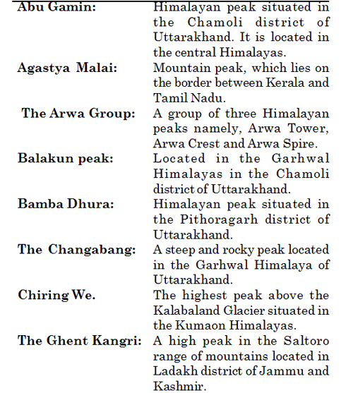
- The Himadri runs in an arc like shape in a length of 2500 km from Nanga Parbat (8126 m) in the west to Namcha Barwa (7756 m) in the east.
- This is the northernmost or the innermost of all the Himalayan ranges.
- With an average elevation of 6100m above sea level and an average width of about 25 km, this is the loftiest and the most continuous mountain range of the world.
Passes of India
Himalayan pass between India and China
Himalayan passes
![]()
- It is about 150km away from the northern edge of the plains of Northern India.
- This mountain range boasts of the tallest peaks of the world, most of which remain under perpetual snow.
- There are many peaks over 8000m in altitude. They are, in descending order of altitude Mount Everest, also called Sagarmatha or Chomo Langma (8848), Lhotse I (8501m , Mount Akalu (8481m), Kanchenjunga South Peak (8474m), Kanchenjunga West Pea (8420m), Lhotsa Intermediate Peak (8410m) Cho Oyu (8153m), Nanga Parbat (8126m) Annapurna (8078m), Gosainthan or Shisha Pangma (8013m), Makalu South peak (8010m).
- Some of the important peaks between 7000 and 8000m elevation are Nanda Devi (7817m), Kamet (7756m), Namcha Barwa (7756m), Gurla Mandhata (7728m), Badri Nath (7138m), Trisul (7138m).
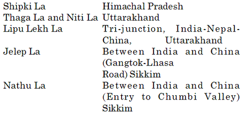
- The Burzil pass and Zoji La in Kashmir, Bara Lapcha La and Shipki La in Himachal Pradesh, Thaga La, Niti Pass and Lipu Lekh Pass in Uttarakhand and Nathu La, Jelep La in Sikkim are worthy of mention.
- The Hindustan - Tibet road connecting Shimla with Gartok in Western Tibet passes through the Shipki La.
- Another important trade route connecting Kalimpong (near Darjeeling) with Lhasa in Tibet however passes through Jelep La (4386m).
- The Himadri runs in an arc like shape in a length of 2500 km from Nanga Parbat (8126 m) in the west to Namcha Barwa (7756 m) in the east.
The Trans Himalayas
- The Himalayan ranges immediately north of the Great Himalayan range are called the trans Himalayas.
- This part of the Himalayan ranges is also called the Tibetan Himalayas because most of it lies in Tibet.
- This is about 40 km wide and consists of fossil bearing marine sediments which are underlain by ‘Tertiary granite’.
- The most important range of the Trans Himalayas is Karakoram range which is called as the “backbone of high Asia”.
- The Zaskar, the Ladakh, the Kailas and the Karakoram are the main ranges of the TransHimalayan system.
- It stretches for a distance of about 1000km in east-west direction and its average elevation is 3000m above mean sea level.
- Satpura range from East to West: Amarkantak - Maikal - Manadeo - Gawilgarn - Rajpipala
- Highest peak in Andaman and Nicobar islands - Saddle Peak
- The highest peak of Naga hills is Saramati peak.
- Hills in Southern Hill complex – Nilgiri, Annaomalai, Cardamom & Palani
- Hills in Eastern Ghats: Shevaroy, Javadi, Palkonda, Nallamalai, Northern Circars
- Oblique ranges to Western Ghats in Maharashtra: Ajanta, Satmala Harishchandra Balaghat
- Highest peak in E Ghats - Mahendragiri (Orissa)
- Highest peak in W Ghats – Anaimudi (Annamalai Hills - Kerala)
- Highest peak in Nilgiris - Doda Betta
- Highest Mt. Peak in India: K2 or Godwin Austin
- Highest peak in Aravalli: Gurushikhar (in Mt Abu)
- Highest peak in Satpura – Dhupgarh (Mahadeo Hills)
- The Zaskar range branches off from the great Himalayan range near 80°E longitude and runs more or less parallel to it.
- The Nanga Parbat (8126m) forms its culmination in the northwest but the adjoining Deosai Mountain may also be included in it.
- North of the Zaskar range and running parallel to it is the Ladakh Range. The Rakaposhi. Haramosh ranges beyond the Indus may be treated as the extension of the Ladakh range to the northwest. The Kailas range (Gangdise in Chinese) in western Tibet is an offshoot of the Ladakh range. The highest peak is Mount Kailas (6714m).
- The northern most range of the Trans Himalayan Ranges in India is the Great Karakoram Range. Karakoram Range extends eastwards from the Pamir for about 800km. It is the abode of some of the greatest glaciers of the world outside the polar regions. Some of the peaks are more than 8000 metre above sea level.
- K2 (8611m) is the second highest peak in the world and the highest peak in the Indian Union.
- The other peaks located in its neighbourhood and rising more than 8000m above sea level are the Gasherbrum I or Hidden Peak (8068m), Broad Peak (8047m) and Gasherbrum II (8035m).
- The Ladakh Plateau lies to the northeast of the Karakoram Range. With an average elevation of over five thousand metres above sea level, it is the highest plateau of the Indian Union.
- It has been dissected into a number of plains and mountains, the most outstanding among them being soda Plains, Aksai Chin, Lingzi Tang, Depsang Plains and Cang Chemmo.
The Eastern Hills or the Purvanchal
-
After crossing the Dihang gorge, the Himalayas take a sudden southward turn and form a series of comparatively low hills running in the shape of a crescent with its convex side pointing towards the west. These hills are collectively called the Purvanchal because they are located in the eastern part of India.
-
The hill ranges running in north-south direction along the Burmese border and passing through Arunachal Pradesh (Tirap division), Nagaland, Manipur and Mizoram are collectively called Purvanchal. These are known by various local names i.e. Patkai Bum (Arunachal Pradesh), Naga hills, Kohima hills, Manipur hills, Mizo hills, Tripura hills and Barail range.
-
Extending from Arunachal Pradesh in the north to Mizoram in the South, they form India’s boundary with Myanmar.
-
In the north is the Patkai Bum, which forms the international boundary between Arunachal Pradesh and Myanmar.
-
After running for some distance southwards, it merges into Naga Hills where Saramati (3826m) is the highest peak.
-
South of Naga Hills are the Manipur hills, which are generally less than 2500 metres in elevation.
-
The Barail range separates Naga Hills from Manipur Hills.
-
South of the Manipur Hills are the Mizo Hills, which have an elevation of less than 1500 metres. The highest point is the Blue Mountain (2157m) in the South.
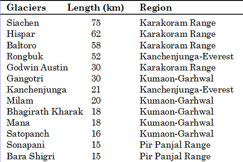
Glaciers of the Himalayan Mountains
Longitudinal Divisions of the Himalayas
Longitudinally, the Himalayas can be divided into following sections:
- The Punjab Himalayas: The 560 km long stretch of the Himalayas between the Indus and the Sutluj rivers is known as the Punjab Himalayas. A large portion of this sector lies in Jammu and Kashmir and Himachal Pradesh as a result of which it is also called the Kashmir and Himachal Himalaya. Karakoram, Ladakh, Pir Panjal, Zaskar and Dhaula Dhar are the main ranges of this section.
- Kumaon Himalayas: This section extends from Sutluj to Kali river valleys and is said to have 360 lakes, such as Naini Tal and Bhim Tal. The Pilgrimage centers (Badrinath, Gangotri) located in this section is of particular importance to the Hindus.
- Nepal Himalayas: This section extends from Kali to Tista and has the distinction of having some of the highest peaks in the world including Mt. Everest.
- Assam Himalayas: This section extends from Tista to Brahmaputra. Pauhunri and Kulhakangari are noted peaks.
II. The Great Plains
- It is an aggradational plain formed by the alluvial deposits of the Indus, Ganga and the Brahmaputra and their tributaries.
- The plain stretches from west (from the banks of the Ravi and Sutluj) to east (the Ganga delta) to a lengh of 2400 km.
- It is about 90-100 km wide in Assam, 160 km near the Rajmahal Hills, 200 km in Bihar, 280 km near Allahabad and 500 km in PunjabRajasthan.
- The plain merges into the Thar Desert in the south-west. A low watershed of the Delhi ridge (278 m) along the right bank of the Yamuna river separates the Satluj plains (a part of the Indus plain) from the Ganga plains.
- According to the recent studies, the average depth of the alluvium has been estimated at about 1300-1400 m which goes on decreasing towards south and finally merging with the irregular edge of the Peninsular block.
Divisions of the Great Plains
-
The Great Plains may be divided into a number of smaller units on the basis of the characteristics of the alluvium, surface gradient, drainage channels and regional traits.
-
Bhabar Plains: It lies all along the foot of the Siwaliks with remarkable continuity from the Indus to the Tista. It is generally 8 to 16 km wide belt consisting of gravel and unassorted sediments deposited by the Himalayan rivers in the foreland zone due to sudden break of slope. The porosity is so high that all streams disappear in the Bhabar tract leaving out only dry channels.
-
Terai Plains: South of the Bhabar lies a 15-30 km wide marshy tract called terai where streams reappear to the surface. The Terai is more marked in the eastern part than in the west due to higher amount of rainfall. It is a zone of excessive dampness, thick forests, rich wild life and malarial climate. ‘
-
Bangar or Bhangar Plains: The Bhangar represents the uplands (alluvial terrace) formed by the deposition of the older alluvium and lie above the flood-limit of the plains. The main constituent of Bhangar is clay which at places gives way to loam and sandyloam.
-
Khadar Plains: The younger alluvium of the flood plains of the numerous rivers is called the Khadar or Bet (in Punjab).
- Its alluvium is light coloured and poor it calcareous matter consisting of deposits of sand, silt, mud and clay.
- Delta Plains: Deltaic plain is an extension of the Khadar plain. It covers about 1.86 lakh sq km of area in the lower reaches of the Ganga, river (West Bengal). It mainly consists of old mud, new mud and marsh.
On the basis of regional characteristics, the Great Plains may be divided into following four meso regions:
-
The Rajasthan Plains: This include: Marusthali and Rajasthan Bagar areas (Stepp lands) to the west of the Aravalli mountains A part of the plain has also been formed by the recession of the sea as is evidenced by the occurrence of several brackish water lakes in the region, i.e. Sambhar, Degana Kuchaman, Pachpadra, Didwana and Lunkaransar Tal from which table salt is obtained.
At present Luni is the only flowing river which reaches the sea. Most of the Rajasthan Plains are covered by vast stretches of sand. Sand dunes cover a large area, the southern and western parts have mostly longitudinal dunes whereas in the eastern and southern parts, where the wind is strong, barkhans and transverse dunes are common. The general slope of the Rajasthan Plain is from east to the west towards the Indus river -
The Punjab-Haryana Plains: The Punjab- Haryana Plains owe their origin to the aggradational activity of the Satluj, the Beas and the Ravi rivers.
The region has two regional slopes, westward towards the Indus river and southwards the Rann of Kachchh. The south-eastern part of the plains bordering the Rajasthan Plains (neat Hissar) is sandy and is characterized by shifting sand dunes. On micro regional basis the Punjab-Haryana Plains may be divided into (a) the Bari Doab (between the Beas and the Ravi), (b) the Bist Doab (between the Beas and the Satluj), (c) the Malwa Plain (occupying the central part of the region) and (d) the Haryana-Bhiwani Bagar in the southern and south-eastern part of the region. -
The Ganga Plains: The Ganga Plains extend from the Yamuna river in the west to the western borders of Bangladesh covering a distance of about 1,400 km and an average width of 300 km.
The maximum height is found near Saharanpur (276m) from where it goes on decreasing towards the Sagar Islands (3 m).
- The Upper Ganga Plain: It occupies a total area of 1,49,029 sq km.
Besides the Ganga and the Yamuna, other important rivers of the region include Ramganga, Gomati, Ghaghara and Rapti etc.
Upper Ganga Plains is divided into three micro units: (i) the Ganga-Yamuna Doab (ii) the Rohilkhand Plain and (iii) the Avadh Plain.- The Middle Ganga Plain: The Middle Ganga Plain includes eastern Uttar Pradesh and the Bihar plains.
There are two large troughs, which may be called Gorakhpur trough and RaxaulMotihari trough of over 8,000 m deep.
Besides Ganga, Gomati, Ghaghara, Rapti, Gandak, Kosi (in the north), and Son (in the south) are other important rivers of the region.
The Kosi, called ‘Sorrow of Bihar’ has shifted its course over 120 km in recent times.
The Middle Ganga Plain can be broadly divided into two sub regions: (a) the Ganga Plain North and (b) the Ganga Plain South. The former is further divided into four micro units: (i) the Ganga Ghaghara Doab, (ii) the Saryupar Plain (iii) the Mithila Plain and (iv) the Kosi Plain. Similarly the Ganga Plain South is subdivided into (v) the Ganga-Son Divide, (vi) the Magadh Plain, and (vii) the Anga Plain.- The Lower Ganga Plain: The Lower Ganga Plain incorporating an area of 80,968 sq km, extends from the foot of the Darjeeling Himalaya in the north to the Bay of Bengal in the south.
The eastern part of the Plain is drained by the rivers (Kartoya, Tista, Jaldhakia Torsa, Sankosh) joining the Brahmaputra, and the western part by the tributaries (Mahananda, Purnabhaba, Ajay, Damodar, Dwarkeswar, Rupnaryan) of Ganga (Padma-Bhagirathi).
4. The Brahmaputra Plains: The Brahmaputra Plains, also called as
Assam Valley, are the easternmost part of the Great Plains drained by the
Brahmaputra and its tributaries.
These plains from Sadiya (in the east) to Dhubri (near Bangladesh border in the
west) are about 720 km long and about 80 km wide covering a total area of about
56,274 sq km. The general altitude of the valley ranges from 130 m in the east
to 30m in the west (Sadiya 130m, Dibrugarh 105m, Sibsagar 97m, Jorhat 87m,
Tezpur 79m, Guwahati 55m, and Dhubri 34m) with an average slope of 12 cm per km.
Majuli (area 929 km2) is the largest river island in the world.
The Assam Valley is divided into two sub regions: (1) Upper Assam Valley and (2) Lower Assam Valley. The Upper Assam Valley include the districts of Lakhimpur and Sibsagar and Tezpur Tahsil of Darrang district. The Lower Assam Valley consists of Dhubri, Goalpara, Barpeta, Kamrup, Nagaon and Darrang districts.
III. The Peninsular Uplands
- Covering an area of 16 lakh sq km, the Peninsular Uplands form the largest physiographic division of India.
- The fault in which the Narmada river flows divides the region into two unequal parts; the smaller one in the north being known as the Central Highlands.
- It is slightly tilted towards north. The southern part has been tilted east with bold heights to the west. This area is popularly known as the Deccan Plateau comprising the Satpuras, Western and Eastern Ghats and a large number of plateaus.
- On the basis of its physiographic characteristics, the Peninsular Upland may be divided into a number of sub-units. These include hill ranges like the Aravallis, Vindhyas, Satpuras, Sahyadris, the Eastern Ghats, plateaus like Chotanagpur, Meghalaya, Deccan, Karnataka, Tamil Nadu, Andhra, Bundelkhand and fertile plains like Malwa, Chhattisgarh etc.
- The Aravalli which runs from north-east to south-west for about 800 km between Delhi and Palanpur (Gujarat) represents a relict of one of the world’s oldest fold mountain systems.
- The range becomes more continuous and rising to above 900 m in the south. Its highest peak lies in Abu hills (Gurushikhar Peak 1722m).
The Malwa Plateau
- Malwa Plateau with a length of 530 km and a width of 390 km, occupies an area of about 15,000 sq. km. It is bordered by the Aravallis in the north, the Vindhyan range in the south and the Bundelkhand Plateau in the east.
- The region has two systems of drainage, one towards the Arabian Sea (Narmada, Tapi and Mahi), and another towards the Bay of Bengal (Chambal and Betwa joining the Yamuna).
- The Western Vindhyas is an escarpment which varies in character and height.
- The Western Satpuras separate the Narmada and the Tapi river basins.
- South-west of Pachmarhi is Dhupgarh (1350 m) which is the highest peak of the Satpuras.
Bundelkhand Uplands
- Bundelkhand Uplands is bounded by the Yamuna river in the north, the Vindhyan Plateau in the south, the Chambal in the northwest and Panna-Ajaigarh ranges in the southeast.
- The region is characterized by ‘senile topography’.
- The streams like Betwa, Dhasan and Ken have carved out steep gorges.
Chhotanagpur Plateau
- The Chhotanagpur Plateau is composed of Archaean granite and gneiss rocks with patches of Dharwar rocks. The Dalma range marks the belt of Archaean lava flows.
- Chhotanagpur consists of a series of plateau standing at different levels of elevation; the highest general elevation of about 1100m in the mid-western portion known as the Pat lands.
- Hazaribagh and Ranchi plateaus standing same general elevation (600m) but separate by the Damodar trough.
- Chhotanagpur is drained in different directions by numerous rivers and streams which the Damodar, Barakar, Subarnarekh North Koel, South Koel rivers have developed extensive drainage basins.
Meghalaya-Mikir Uplands
- The Meghalaya-Mikir Uplands consisting of the Garo, Khasi, Jaintia and the outlying Mikir and Rengma hills is a tableland which has been detached from the Indian Peninsula by the Malda Gap.
- It is bordered by the Dhansiri river in the east and the Singimari in the west.
- The Shillong peak (1961 m) is the highest peak of the area.
- Mikir Hills are detached from the Meghalaya Plateau and are surrounded by plains on three of sides.
- The southern ranges known as the Rengma Hills have an average elevation of 900m. The area is characterized by radial drainage with Dhansiri and Jumna being the main rivers.
Maharashtra Plateau
- The basaltic sheet has a thickness of more than 2,000 m and has been formed by the consolidation of the lava that erupted subaerially about 60 to 65 million years ago.
- It is sometimes difficult to distinguish the Deccan Plateau from the Sahyadri.
Mahanadi Basin
-
The Mahanadi Basin is also called Chhattisgarh Plain. The Mahanadi with its tributaries like Seonath, Hasdo, Mand etc drain this area and form the radial pattern. The area is characterized by red and yellow soils which are suitable for rice cultivation.
-
The Chhattisgarh Plain is bordered by a series of hills and plateaus. The northern boundary is formed by the Lormi plateau, Pendra plateau, Chhuri hills and Raigarh hills. This area is largely formed by ancient granites and gneisses with their characteristic rounded rolling topography.
-
The Durg Uplands are rounded and rolling granitic and gneissic areas. The southern rimland includes the Rajhara Hills in southern Durg district and the Raipur Uplands in southeastern Raipur district (300-500m). The Rajhara Hills contain Dharwarian rocks in which iron ore is mined for Bhilai steel plant
Dandakaranya Region
- Its Abujhmar hills provide one of the richest iron-ore deposits at Bailadilla Range.
Karnataka Plateau
- The region has an average elevation between 600-900m. Mulangiri (1923m) is the highest peak (Baba Budan hills) followed by Kudremukh (1892m).
Telangana Plateau
- The region has two small physiographic units:
- Telangana, and (ii) Rayalaseema Upland. The Telangana is a long belt of peneplains mainly developed over the gneissic rocks. Its northern and north-eastern margin is occupied by the Godavari valley which is distinct due to its faulted structure.
- The Rayalaseema Upland is divided by the Penner.
- The Rayalaseema Plateau is a vast tableland forming northward extension of the Karnataka Plateau.
The Sahyadris
- The Sahyadris or Western Ghats run parallel to the western coast for about 1,600 km in north-south direction from the mouth of the Tapi river to Cape Comorin.
- These are block mountains formed due to the downwarping of a part of the land into the Arabian Sea. Sahyadris form the real watershed of the Peninsula.
- In the Nilgiris, the Eastern Ghats join the Sahyadris to form a mountain knot whose highest point is Doddabetta (2637 m).
The Eastern Ghats
- The Eastern Ghats form the eastern boundary of the Deccan Plateau.
- These are a series of detached hills of heterogeneous composition which are called by various local names.
- Their average elevation is 1100 m. They depict true mountain characteristics between the Mahanadi and Godavari.
- The predominant rocks are khondalites and charnokites.
- Between the river Krishna and Chennai they continue as the Kondavidu hills mainly composed of quartzites and slates.
- The Nallamalai (900-1100 m height) and Palkonda hills are composed of Cuddapah and Kurnool formations.
- The last stretch beyond Chennai is formed primarily of charnokites together with gneiss, crystalline limestone, quartzites and mica-schits.
- The Nilgiris (Blue Mountains) provide the converging site for three mountain ranges: the Sahyadri joining opposite of the Mukurti peak; the southern Ghats across the Palghat in the south and the Eastern Ghats at the north-eastern corner.
The Vindhyan Range
- The Vindhyan Range extending from Jobat in Gujarat to Sasaram in Bihar runs for about 1,050 kms.
- It is a relict mountain whose rock formations date back to the pre-Cambrian period.
- The Maikal range, forming a connecting link between the Vindhyas and the Satpuras, is a large plateau.
- The Vindhyan range together with Satpura form the watershed of central India from which rise the Narmada, Chambal, Betwa, Tons, Ken Son and other rivers some of which flow into the Ganga and others into the Godavari and Mahanadi.
The Satpura Range
-
Parallel to the Vindhyas between the valleys of the Narmada in the north and that of the Tapi in the south, lies the Satpura range which extends from Ratanpur in the west to Amarkantak in the east. It has a total length of about 900 km and average height of 770 m. Structurally the Satpura range has three parts. (i) Rajpipla hills (width 60 km) in the western part with steep slopes. (ii) The Mahadeo hills system and pink sandstones. (iii) The eastern part consisting of Maikal range is composed of Gondwanas and Archaean gneisses.
IV. The Indian Coasts and Islands
- The Peninsular Uplands are flanked by coastal plains of varied width extending from Kachchh to Orissa.
- With the notable exception of Gujarat the west coast has a narrow alluvial margin interspersed by hilly terrain and characterized by more wet climate.
- It is a submerged coast.
- The backwaters are the characteristic features of this coast.
- From Kachchh to Cape Comorin it has a total length of 1,840 km.
- The East Coast Plains are broader, associate with depositional activity of rivers.
- It stretches about 1,800 km from Mahanadi mouth to Cape Comorin. It is a coast of emergence in which the deltas of Mahanadi, the Godavari, the Krishna, the Kaveri etc. are characteristic features of the coast.
Division of the Indian Coastal Plains
- Physiographically the Indian coastal plain may be sub-divided into following three broad divisions: (a) Gujarat Coastal Plain, (b West Coastal Plain, and (c) East Coastal Plain
Gujarat Coastal Plain: It is formed by the alluvial deposits of the Sabarmati, Mahi and numerous tiny parallel consequent streams whose process of formation is still continuing. The region consists of major an( minor peninsulas, gulfs, islands, ranns, creeks marshes, hills, plateaus etc.
West Coastal Plain: West Coastal Plain lies between the Sahyadris and the Arabian Sea. It is mainly characterized by sandy beaches, coastal sand dunes, mud flats, lagoons, alluvial tracts along rivers, estuary, laterite platforms and residual hills. The West Coastal Plain may be sub-divided into three main regions (i) the Konkan, (ii) the Karnataka or Kanara, and (iii) the Kerala or Malabar. The Konkan Coastal Plain consists of undulating lowlands. It is widest near Mumbai, in ‘the amphitheatre-like basin of the Ulhas’.
- The Karnataka Coastal Plain depicts (i) a narrow belt of very recent deposits, (ii) an erosion platform, (iii) inland belt of isolated hills of Archaean gneisses.
- The Malabar Coast is narrower in the north and south and wider in the middle section.
c. East Coastal Plain: It lies between the Eastern Ghats and the Bay of Bengal and is more extensive and wide than its western counterpart. These plains are formed by the alluvial fillings of the littoral zone comprising some of the largest deltas of the world.
- The East Coastal Plains mainly consist of recent and tertiary alluviums.
- The region has a straight shoreline with well defined beaches of sand and shingles.
- The most famous beach is the Marina Beach in Chennai.
- The Chilka lake in the south-west of the Mahanadi delta is the biggest lake of our country.
The Indian Islands
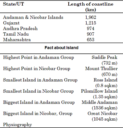
- India has a total of 247 islands of which 204 lie in the Bay of Bengal and remaining in the Arabian Sea.
- The Bay islands consisting of Andaman and Nicobar group of islands have a crescents shape and denote the peaks of submerged Tertiary mountain ranges - a continuation of the Arakan Yoma fold axis.
- The Arabian Sea islands have a coral origin and are surrounded by fringing reefs.
- Besides there are a number of offshore islands along the Ganga-mouth, eastern and western coasts and in the Gulf of Mannar.
(a) Arabian Sea Islands: The Arabian Sea islands comprise 36 islands of Lakshadweep Group.
- Only 25% of the area is inhabited.
- The southern most island (Minicoy) is separated from the rest of the group by the 9 degree channel.
- The northern most group is collectively known as Amindivi Islands.
- Similarly the central group is collectively called as Laccadive Islands.
- In the south the Lakshadweep is separated from Maldive Islands by Eight Degree Channel.
Ethnic Groups
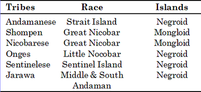
(b) Bay of Bengal Islands: The Andaman and Nicobar group of islands are separated from each other by the 10 degree Channel. The extreme southern most point is Indira Point (Pygmalion Point or La Henching) at 6.7°N and 93.8°E.
- The Andaman Group of Islands include 204 islands. There are two volcanic islands, e.g. Barren and Narcondam.
- The Nicobar Group of Islands comprises 18 islands. These are separated from the Andaman group of islands through 10 degree Channel which represents a fracture zone. Some of the Nicobar islands like Chowra, Car Nicobar and Pulo Milo are essentially coral, while Katchall, Nancowry and Great Nicobar are hilly as are the Andamans.
(c) Offshore Islands: India has a number of islands along the Western, Eastern coasts. Among Western coast islands mention may be made of Piram, Bhaisala (Kathiawar); Diu, Vaida, Nora (Kachchh coast); Aliabet (Narmada-Tapi mouth); Elephanta, Salsette, (near Mumbai); Pamban, Crocodile (Gulf of Mannar); Sri Harikota (mouth of Pulicat lake); Parikud (mouth of Chilka lake) and New Moore and Sagar (Ganga delta).
Fact about Longest Coastline