(Sample Material) Online Coaching for CAPF (AC): Geography - "World Geography (Part - 2)"
Online Coaching for UPSC Central Armed Police Forces (AC) Written Examination
Geography
World Geography (Part - 2)
Lithosphere
- Earth, the home to mankind, is a unique member of the solar family.
- The fifth biggest planet in the solar system, its uniqueness lies in its habitability.
- Its interior, surface and surroundings are so conditioned that life, in all its manifestations, is sustained in a state of utmost harmony.
- Earth is one of its kinds because of the presence of life-giving air and water.
- It also boasts of a gravitational pull that binds the atmosphere and hydrosphere, making life possible on Earth.
Earth’s Shape
- The true form of Earth resembles a sphere that has been compressed along the polar axis and made to bulge slightly around the equator.
- This form is known as an oblate ellipsoid.
- The oblateness is caused by the centrifugal force of the Earth’s rotation, which deforms the somewhat plastic Earth into a form that is in equilibrium with respect to the forces of gravity and rotation.
- The shape of Earth is best described as a ‘geoid, meaning Earth-shaped.
Tilt of the Earth’s Axis
-
The axis of the Earth is inclined to the plane of ecliptic (the plane in which the Earth orbits round the sun) at an angle of 66'/2°, giving rise to different seasons and varying lengths of day and night.
-
If the axis were perpendicular to this plane, all parts of the globe would have had equal days and nights at all times of the year.
-
The sun is vertically overhead at the equator on two days each year, i.e. on March 21st and September 23rd. These days are called equinoxes meaning ‘equal nights’ because on these two days all places on Earth have equal days and nights.
-
After the March equinox, the sun appears to move northwards and is vertically overhead at the Tropic of Cancer on June 21st. This is known as the summer solstice, when the northern hemisp-here will have its longest day and shortest night.
-
By December 22nd, the sun is overhead at the Tropic of Capricorn. This is the winter solstice when the southern hemisphere will have its longest day and shortest night.
Movement of Earth
- The earth moves in space in two distinct ways. It rotates on its own axis from west to east once in every 24 hours causing day and night.
- It also revolves round the sun in an orbit once in every 365 1/4 days causing the season’s and the year.
- The earth revolves round the sun in an elliptical orbit at a speed of 18.5 miles per second.
- A normal year is taken to be 365 days, and an extra day is added every four years as a Leap Year because 1 /4th day of every year becomes 1 day.
Latitudes and Longitudes
- Latitude is the angular distance of a point on the Earth’s surface, measured in degrees from the centre of the Earth.
- Longitude is the angular distance, measured in degrees along the equator, east or west of the Prime Meridian (the meridian that passes through Greenwich near London).
- This is the meridian from which all other meridians radiate eastwards and westwards up to 180°.
- Longitudes are not used for calculating distances, since there is so much difference in the length of degrees of longitude outside the tropics.
- But they have one very important functionthey help in determining local time in relation to Greenwich Mean Time (GMT).
Standard Time and Time Zones
- Most countries adopt their standard time from the central meridian of their countries.
- The whole world has been divided into 24 Standard Time Zones.
- Each zone, therefore, is separated by 15° longitudes or by one hour.
- Larger countries like USA, Canada and Russia having greater east-west stretch have to adopt several time zones.
- Both USA and Canada mainland have five time zones each- the Atlantic, Eastern, Central, Mountain and Pacific. Russia has 11 time zones.
- Interestingly, despite a considerable east-west stretch, India has only one time zone.
Earth’s position with respect to Moon
- Apogee: The period of the farthest distance between the moon and the earth - (407,000km) is called apogee.
- Perigee: The period of the nearest distance between the moon and the earth (356,000 km) is called perigee.
Earth’s position with respect to Sun
- Perihelion: The period of the nearest distance between the earth and the sun (147 million kilometer) is perihelion. It happens on January 3.
- Aphelion: The period of the farthest distance between the earth and the sun (152 million kilometres) is called aphelion. It happens on July4.
Earth’s Interior
- Temperature inside the Earth increases with depth.
- Experiments have confirmed that the temperature increases at the rate of 1°C for every 32 metres.
- With this rate of increase all the matter at the Core should have been in a molten state, but since the pressure at such great depths is also very high, the melting point is higher than the prevalent temperature and the inner Core is in a solid state.
- In the outer Core, however, the pressure is lesser and the matter is in a liquid state.
- The Core and the Mantle are separated by the Guttenberg discontinuity, while the Mohorovicic discontinuity separates the Mantle from the Crust.
- Besides, the upper granitic and the lower basaltic layers of the crust are separated by a seismically determinable boundary called the Conrad discontinuity.
- The uppermost portion of the mantle on which the crust rests, is rigid.
- The crust and this solid uppermost mantle are together called lithosphere, the sphere of rocks.
- Below the lithosphere, the upper mantle becomes so hot that it resembles hot plastic.
- This soft plastic layer in upper mantle is called the asthenosphere.
- The hot plastic character of the asthenosphere and the convective heat cells facilitate the movement of lithospheric plates overlying this layer.
Earth’s Magnetic Field
- The Earth’s magnetic poles do not coincide exactly with the geographic poles.
- Earth’s magnetic field reverses polarity; that is, the north magnetic pole becomes the south magnetic pole and vice versa.
- However, it is not yet known exactly how the Earth’s magnetic field is produced.
Plate Tectonics
- The theory of Plate Tectonics states that the lithosphere consists of several individual segments called plates.
- About twenty such plates have been identified.
- Of these, the largest is the Pacific plate while the Juan de Fuca plate, off the western coast of North America, is the smallest.
- Most of the Earth’s seismic activity, vulcanism and mountain building occur along these dynamic margins.
- A convergent plate boundary is, one where two plates collide, one plate bending downward and subducting below the other.
Continental Drift Theory
-
F B Taylor postulated his concept of ‘horizontal displacement of the continents’ in the year of 1908 to explain the problems of the origin of the folded mountains of tertiary period.
-
Alfred Wegener propounded his concept on continental drift in the year 1912 which is also known as displacement hypothesis. It was propounded to explain the global climatic changes.
-
The concept of sea floor spreading was first propounded by professor Hary Hess in the year 1960.
-
Depending on the type of movement, plate margins are of three types-Divergent, Convergent and Transform fault boundaries.
-
When plates move apart with the upwelling of material from the mantle, a divergent plate boundary results.
-
The conspicuous mid-Atlantic Ridge system wherefrom the Atlantic Ocean is widening; the Red Sea that is driving a wedge between Africa and the Arabian Peninsula and the Great Rift Valley of Africa are examples of such divergent plate boundaries.
-
Collisions can occur between two oceanic plates, one oceanic and one continental plate or two continental plates.
-
A deep-ocean trench is formed adjacent to the zone of subduction while the upwelling magma generated by a complex process of melting of the subducting crust cause explosive volcanic eruptions.
-
The volcanic portions of the Andes Mountains have been formed by the subduction of the Nazca plate below the continent of South America.
-
The mechanism is similar in the case of an ocean-ocean convergence except that the chain of volcanoes forms on the ocean floor rather than on land. Island arcs like the Aleutian, Mariana and Tonga exemplify such convergence. Oceanic trenches viz. the Aleutian, Mariana and Tonga parallel such Island arcs.
-
The collision of the Indian plate against the Eurasian plate, leading to the formation of the spectacular Himalayas is an example of continent-continent convergence.
-
Prior to the collision, the landmasses were separated by oceanic crust which in the case of the Himalayas was the Tethys Sea.
-
Youngest fold mountain of the world continues to rise even today.
-
The third type of plate boundary is the transform fault, which is located where plates slide past one another without the creation or destruction of crust.
-
Transform faults provide the means by which the oceanic crust created at the divergent plate margins can be transported to its site of destruction, the deep-ocean trenches.
-
These faults are so called because the relative motion of the plates can be ‘transformed’ along them.
-
The relative motion of the North American plate occurs along the famous San Andreas Fault, which is one of the most seismically active faults of the world.
Vulcanism and Earthquakes
Vulcanism
- It is the eruption of molten rock at the earth’s surface, often accompanied by rock fragments and explosive gases.
- Vulcanism and the degassing of Earth gave Earth its atmosphere.
- Lava, dust and pyroclasts spewed out from volcanoes cause widespread devastation.
- Greatest volume of volcanic matter is produced along the oceanic ridge systems that are essentially divergent plate boundaries.
- Such volcanic activity had led to the sudden formation of the Surtsey Island, south of Iceland, in 1963.
- The ‘Ring of Fire’, which is the most active volcanic belt bordering the Pacific Ocean, is associated with subduction plate boundaries.
- The numerous volcanoes dotting the sea off Philippines, Japan, the Aleutian Islands and the volcanoes of the Andes mountains, are all examples of subduction zone vulcanism.
- Volcanoes may also occur within a rigid plate, but the processes that lead to such in-plate vulcanism are difficult to explain.
- The volcanic Islands of Hawaii in the midPacific and the famous hot water geysers of the Yellowstone region of North America are examples of such in-plate volcanoes.
Distribution of Volcanic Activity
- Most vulcanism not associated with seafloor spreading is related to subduction zones and is concentrated at convergent plate boundaries.
- But some volcanic activities are associated neither with mid-oceanic ridges nor with subduction zones.
- These are regions of local magmatic extrusions, which are popularly known as the hotspots.
- The island of Hawaii, for example, lies in an archipelago in the middle
of the Pacific. ‘
On the African Plate, where West Africa and Equatorial Africa meet (at Africa’s so-called “armpit”), lies Mt. Cameroon, another active volcano far from spreading ridges and subduction zones.
Active Volcanoes
- Mt Etna (Mediterranean Sea)
- Stromboli (Mediterranean Sea)
- Pinatubo (Phillippines)
- Mayon (Phillippines)
- Cotapaxi
- Fuziyama
- Shasta
- Rainier
- Kilavea
- Volcanoes have been traditionally differentiated into active, dormant and extinct.
- An active volcano is one that has erupted in recorded history, like Barren Islands in India and Mt. Stromboli in Italy.
- A dormant volcano has not been seen to erupt, but it shows evidence of recent activity, like Mt. Kilimanjaro.
- When a volcano shows no sign of life and exhibits evidence of long-term weathering and erosion, it is tentatively identified as extinct.
- Interestingly, there is no clear cut definition of an extinct or a dormant volcano.
Earthquakes
- An earthquake is basically the vibration of Earth produced by the rapid release of energy.
- This energy radiates in all directions from the source, focus, in the form of waves.
- The waves are very much analogous to those produced when a stone is dropped into a campond.
- Seismic sensors, called seismographs, located throughout the world can record the event.
- It is estimated that over 30,000 earthquakes, strong enough to be felt, occur worldwide annually.
- Fortunately most of these are minor tremors and do very little damage and only about 75 significant earthquakes take place each year.
- The intensity of an earthquake and the destruction it causes are greater over softer soil regions, for example on alluvial soils, than on more rocky areas.
- Sometimes, the tremendous energy released by atomic explosions or by volcanic eruptions can also produce earthquakes, but these events are usually too weak and infrequent.
- The Himalayas, making the great mountain wall of the north, also happen to form the northern margin of the Indian plate and hence are marked by frequent and severe earthquakes.
- Seismicity may also occur away from such regions. Such seismic activities, located within the plates away from the plate margins, are called in-plate seismicity.
- They are generally confined to the weaker zones of the earth’s crust.
- These weaker zones are represented by faults or fractures within the earth’s crust and are generally less intense than the ones found near the plate margins.
- One such zone of in-plate seismicity is the Narmada-Son lineament, cutting across the northern plane.
- The earthquake of January 26, 2001 which flattened parts of Gujarat was also caused by the growing ‘in-plate stress’ in the region.
- In fact, the whole Kutch is a fault. Bhuj, which bore the brunt of the nature’s fury, lies close to the Allah bund fault.
- Hence, in-plate seismicity is due to the reactivation of concealed shields (stable parts of the Earth) and release of energy.
Earthquake Waves
Earthquakes generate pulses of energy called seismic waves that can pass through the entire Earth. Three major divisions of seismic waves have been recognized:
- Primary (P) Waves, of short wavelength and high frequency, are longitudinal waves which travel not only through the solid crust and mantle but also through the liquid part of the earth’s core.
- Secondary (S) Waves, of short wavelength and high frequency, are transverse waves which travel through all the solid parts of the Earth but not the liquid part of the core.
- Long (L) Waves, of long wavelength and low frequency, are confined to the skin of the earth’s crust, thereby, causing most of the earthquakes structural damage.
Seismic Zones of India
- Based on the intensities of earthquakes recorded on the Modified Mercalli scale, India is divided into five seismic zones.
Zone 1 Intensity V or below
Zone 2 Intensity VI
Zone 3 Intensity VII
Zone 4 Intensity VIII
Zone 5 Intensity IX and above
- ‘Zone 5’ covers areas with a probable magnitude of 8 or more on the Richter scale.
- Zone 1 is the least seismic prone zone with magnitude of up to 4.9 on the Richter scale.
- Delhi falls in ‘Zone 4’ and is prone to earthquakes of magnitude between 7 and 7.9 on the Richter scale.
- The Rann of Kutch, the entire Northeast, the Andamans, certain parts of Jammu and a good part of Uttaranchal come under ‘Zone 5’.
Rocks and Minerals
- Rocks are made up of individual substances, which are called minerals found mostly in a solid state.
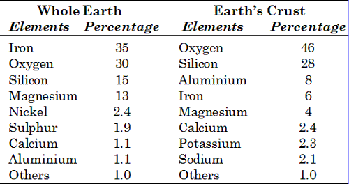
- Each mineral usually contains two or more simple substances called elements of which the whole earth is made.
- Out of about 2,000 different minerals, only twelve are common all over the earth.
- These twelve minerals are called the rock-formers.
- The common minerals are formed of eight most abundant elements in nature.
- Out of these, silicates carbonates and oxides make up a large group of them.
- As many as 87 per cent of the minerals in earth’s crust are silicates.
- Quartz, for example, has two elements, silicon and oxygen, united together form a compound known as carbonate of lime.
<< Go Back To Main Page