(IGP) GS Paper 1 - India & World Geography - "Lithosphere"
Integrated Guidance Programme of General Studies for IAS (Pre)
Subject - India & World Geography
Chapter : Lithosphere
Our Planet Earth:
- Earth, the home to mankind, is a unique member of the solar family.
- The fifth biggest planet in the solar system, its uniqueness lies in its habitability vertically overhead at the equator on two days each year, i.e. on March 21st and September 23rd. These days are called equinoxes meaning ‘equal nights’ because on these two days all places on Earth have equal days and nights.
- After the March equinox, the sun appears to move northwards and is vertically overhead at the Tropic of Cancer on June 21st. Thus is known as the summer solstice, when the northern hemisphere will have its longest day and shortest night.
- By December 22nd, the sun is overhead at the Tropic of Capricorn. This is the winter solstice when the southern hemisphere will have its longest day and shortest night.
Movement of Earth:
- The earth moves in space in two distinct ways. It rotates on its own axis from west to east once in every 24 hours causing day and night.
- It also revolves round the sun in an orbit once in every 365 ¼ days causing the seasons and the year.
- The earth revolves round the sun in an elliptical orbit at a speed of 18.5 miles per second.
- A normal year is taken to be 365 days, and an extra day is added every four years as a Leap Year because 1/4th day of every year becomes 1 day.
Latitudes and Longitudes:
- Latitude is the angular distance of a point on the Earth’s surface, measured in degrees from the centre of the Earth.
- Longitude is the angular distance, measured in degrees along the equator, east or west of the Prime Meridian (the meridian that passes through Greenwich near London).
For Detail Description, Analysis and More MCQs of the Chapter Buy this Study Notes:

Standard Time and Time Zones:
- Most countries adopt their standard time from the central meridian of their countries.
- The whole world has been divided into 24 Standard Time Zones.
- Each zone, therefore, is separated by 15º longitudes or by one hour.
- Larger countries like USA, Canada and Russia having greater east-west stretch have to adopt several time zones.
International Date Line:
- The International Date Line in the mid-Pacific curves from the normal 180º meridian at the Bering Strait, Fiji, Tonga and other island to prevent confusion of day and date in some of the island groups that are cut through by the meridian.
Earth’s position with respect to Moon:
- Apogee: The period of the farthest distance between the moon and the earth (407,000km) is called apogee.
- Perigee: The period of the nearest distance between the moon and the earth (356,000 km) is called perigee.
Earth’s position with respect to Sun:
- Perihelion: The period of the nearest distance between the earth and the sun (147 million kilometer) is perihelion. It happens on January 3.
- Aphelion: The period of the farthest distance between the earth and the sun (152 million kilometers) is called aphelion. It happens on July 4.
Earth’s Interior:
- Temperature inside the Earth increases with depth.
- Experiments have confirmed that the temperature increases at the rate of 1ºC for every 32 metres.
- The Core and the Mantle are separated by the Guttenberg discontinuity, while the Mohorovicic discontinuity separates the Mantle from the Crust.
- Besides, the upper granitic and the lower basaltic layers of the crust are separated by a seismically determinable boundary called the Conrad discontinuity.
Plate Tectonics:
- The theory of Plate Tectonics states that the lithosphere consists of several individual segments called plates.
- About twenty such plates have been identified.
- Of these, the largest is the Pacific plate while the Juan de Fuca plate, of the western coast of North America, is the smallest.
Continental Drift Theory:
- F B Taylor postulated his concept of ‘horizontal displacement of the continents’ in the year of 1908 to explain the problems of the origin of the folded mountains of tertiary period.
- Alfred Wagener propounded his concept on continental drift in the year 1912 which is also known as displacement hypothesis. It was propounded to explain the global climatic changes.
Sea Floor spreading:
- The concept of sea floor spreading was first propounded by professor Hary Hess in the year 1960.
- Collisions can occur between two oceanic plates, one oceanic and one continental plate or two continental plates.
- A deep-ocean trench is formed adjacent to the zone of subduction while the upwelling magma generated by a complex process of melting of the subducting crust cause explosive volcanic eruptions.
Earthquakes:
- An earthquake is basically the vibration of Earth produced by the rapid release of energy.
- This energy radiates in all directions from the source, focus, in the form of waves.
- The waves are very much analogous to those produced when a stone is dropped into a calm pond.
- Seismic sensors, called seismographs located throughout the world can record the event.
Earthquake Waves:
- Earthquakes generate pulses of energy called seismic waves that can pass through the entire Earth. Three major divisions of seismic waves have been recognized:
- Primary (P) Waves of short wavelength and high frequency are longitudinal waves which travel not only through the solid crust and mantle but also through the liquid part of the earth’s core.
- Secondary (S) Waves, of short wavelength and high frequency, are transverse waves which travel through all the solid parts of the Earth but not the liquid part of the core.
- Long (L) Waves, of long wavelength and low frequency, are confined to the skin of the earth’s crust, thereby, causing most of the earthquakes structural damage.
Seismic Zones of India:
- Based on the intensities of earthquakes recorded on the Modified
Mercalli scale, India is divided into five seismic zones.
Zone 1 Intensity V or below
Zone 2 Intensity VI
Zone 3 Intensity VII
Zone 4 Intensity VIII
Zone 5 Intensity IX and above
‘Zone 5’ covers areas with a probable magnitude of 8 or more on the Richter scale. - Zone I is the least seismic prone zone with magnitude of up to 4.9 on the Richter scale.
- Delhi falls in ‘Zone 4’ and is prone to earthquakes of magnitude between 7 and 7.9 on the Richter scale.
- The Rann of Kutch, the entire Northeast, the Andamans, certain parts of Jammu and a good part of Uttaranchal come under ‘Zone 5’.
Classification of Rocks:
On the basis of the mode of formation, rocks are usually classified into three major types:
1. Igneous Rocks
- Igneous rocks are parents of all other rocks and are also known as primary rocks.
- They have been forming since earth began and are still formed in regions of volcanic activity.
- Extrusive igneous rock is the name given to magma eruption and solidifying after escape of gases as lava on reaching the surface of earth.
- Basalt is a typical example of extrusive type, covering 500,000 sq km of Peninsular India in its north-western part.
- The intrusive igneous rock is formed by solidification of magma at moderate depths beneath the earth’s surface.
- The granite and the dolerite are the most common examples of such rocks.
2. Sedimentary Rock
- Although three-fourths of the earth’s surface is covered with sedimentary rocks, they make up only about 5 per cent of the volume of the earth’s crust.
- As sedimentation is favoured by water, most of the sedimentary rocks have been formed under water.
- The loess is one example of fine sand carried by wind and deposited as wind-borne sedimentary rock as in north-western China and Indian subcontinent.
- The conglomerate is a collection of round pebbles taken from a sea shore or a riverbed mixed and bound together by some cementing stuff.
- Two well-known examples of sedimentary rocks of organic origin are coal and the limestone.
3. Metamorphic Rocks
- In Greek language, the word ‘metamorphic’ means ‘change of form’.
- These rocks are formed under conditions similar to those producing igneous rocks.
- The process of metamorphism takes place at depths under the pressure of overlying rocks or as a result of contact with a hot igneous material.
Important Metamorphic rocks
Basic rocks Metamorphosed
Limestones Marbles
Sandstones Quartzites
Shales/Clays Slates/Schist
Granites Gneisses
Gabbro Serpentine
Amphibolites Basic granulites
Basaltic rocks Eclogite
Classification of Landforms:
- There are three major landforms- mountains, plateaus and plains.
Mountains
- An uplifted portion of the earth’s surface is called a hill or a mountain.
- In our country, a mountain is differentiated from a hill, when its summit or top rises to more than 900 metres above the base.
- Those with less than this elevation are called hills.
- On the basis of their origin or mode of formation, the mountains are classified as structural or tectonic, residual or dissected and volcanic.
Plateaus
- A plateau is an elevated area generally in contrast to the nearby areas.
- It has a large area on its top unlike a mountain and has an extensively even or undulating surface.
- The rocks of the plateau are layered with sandstones, shale’s and limestones.
- The great Deccan Plateau with its slope towards east is a tilted plateau in our country.
- The plateaus are of three types on the basis of their situation (i) intermontane, (ii) continental, (iii) piedmont plateaus and (iv) Lava plateaus.
Plains:
- A relatively flat and a low-lying land surface with least difference between its highest and lowest points is called a plain.
- A plain may be as low as 30 metres to the east of Mississippi river near the Appalachian range and as high as 1,500 metres above sea level to the west of the river.
- Plains can be placed according to their position and surface relief but are better classified on the basis of their mode of formation.
- They are sub-divided into structural, erosional and depositional plains.
Drainage Patterns:
- The riverine topography develops in fully evolved drainage basin.
- A main stream or a river with all its tributaries produces a river system or a drainage basin.
- The higher ground separating the two drainage basins is called the watershed or a water divide.
- The uplands or the mountains through which a river flows describe its catchment area from over which it draws its water.
- Originally when rivers flow in the direction of the slope or as a consequence of the slope, they are called the consequent streams.
- As soon as such a river is joined by its tributary, it is called the subsequent stream.
Delta:
- The depositional feature of almost triangular shape at the mouth of a river debouching either in lake or a sea is called delta.
- The word ‘delta’ derived from Greek letter, was first used by Greek historian Herodotous for the triangular depositional feature at the mouth of the Nile river.
- An average delta consists of three beds of sediments e.g. (i) topset beds, (ii) foreset beds and (iii) bottom set beds.
Ground Water:
- There are about 1360 million km3 of water in the world of which 1322 million km3 are in the oceans.
- Of the remaining 4 million km3, 76.8 per cent is locked up in ice caps and glaciers, 22.6 percent is in ground water (water below the surface), 0.56 per cent is in surface water (streams, rivers and lakes), and only 0.04 per cent is in the atmosphere in the form of water vapour.
Estuaries:
- Fresh water from land enters the ocean through rivers, streams and ground water.
- The embayment’s where fresh water from the land meets salt water from the ocean are called estuaries.
- The most commercially important and heavily populated estuaries are the mouths of major rivers.
Artesian Wells:
- It is special type of well, which owing to the nature of its formation is quite distinctive.
- Here, rock layers are down-folded into a basin shape so that permeable strata may be sandwiched between impermeable layers.
- The impermeable layer below prevents the water from passing downwards while the impermeable layer on top prevents any possibility of water escaping upwards. Such a structural basin is called an aquifer.
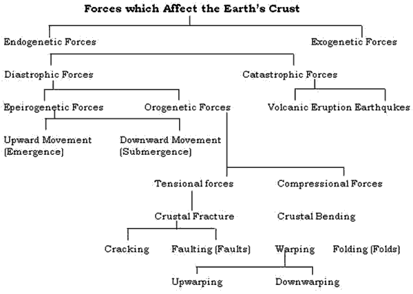
- Endogenetic Forces: The forces coming from within the earth are called endogenetic forces which cause two types of movements in the earth viz. (i) Horizontal movements and (ii) Vertical movements.
-
Exogenetic Forces: The exogenetic forces or processes, also called as denudational processes, or destructional forces or processes are originated from the atomosphere. They are also known as plantation processes. Denudation includes both weathering and erosion.
For Detail Description, Analysis and More MCQs of the Chapter Buy this Study Notes: