UPSC Geo-Scientist and Geologist Exam Papers 2018 : Geology Paper- I
![]()
(Download) UPSC: Geologist Examination Papers-2018
Exam Name : UPSC Geo-Scientist and Geologist Exam
Subject : UPSC Geo-Scientist and Geologist Exam Papers 2018 : Geology Paper- I
Year : 2018
GEOLOGY Paper - I
Time Allowed : Three Hours
Maximum Marks : 200
Question Paper Specific Instructions
Please read each of the following instructions carefully before attempting questions :
There are ELEVEN questions divided under SIX sections.
Candidate has to attempt SIX questions in all. The ONLY question in Section A is compulsory. Out of the remaining TEN questions, the candidate has to attempt FIVE, choosing ONE from each of the other Sections B, C, D, E and F.
The number of marks carried by a question/ part is indicated against it.
Symbols, abbreviations and notations have their usual standard meanings.
Attempts of questions shall be counted in sequential order. Unless struck off, attempt of a question shall be counted even if attempted partly.
Any page or portion of the page left blank in the Question-cum-Answer Booklet must be clearly struck off.
Answers must be written in ENGLISH only.
Neat sketches are to be drawn to illustrate answers, wherever required.
Wherever required, graphs/tables are to be drawn on the Question-cum-Answer Booklet itself.
SECTION A (Compulsory Section)
Q1. Answer and/or describe the following in brief with diagrams wherever necessary :
(a) Types of atmospheric scattering exhibited by electromagnetic radiation.
(b) Draw a neat labelled sketch of a soil profile.
(c) City 'A' lies in toposheet number 78 I/16, City 'B' lies in another
toposheet to the east of 78 I/16. Name the toposheet number of City 'B'. If map
separation between A and B is 10 cm, what is the ground distance ? (Scale of the
toposheet is 1 : 50,000)
(d) How is sense of shear determined with S-C fabric, a
and b type porphyroclast and intra granular fault ?
(e) Pan-African Rejuvenation of Southern Granulite Terrane.
(f) Subduction Zone
(g) Stratigraphy of Central India Tectonic Zone
(h) Arrange the following igneous suites in chronological order, mentioning
their isotopic ages and stratigraphic units :
(i) Malani Igneous Suite
(ii) Dongargarh Granite
(iii) Closepet Granite
(iv) Singhbhum Granite
(v) Deccan Basalt
(i) Life cycle of Agamont and Gamont
(j) Allopatric Speciation
SECTION B (Attempt any one question)
Q2. (a) Describe the IRS system satellite programme with special emphasis on the sensor system used in each and their characteristics. Comment on the utility of remote sensing images for societal benefit.
(b) Write short notes on the following:
(i) Types of drainage patterns
(ii) Erosional features formed by wind
(iii) Stream length gradient index
Q3. (a) Discuss the different types of aerial photographs. Comment on
their utility in geological studies.
(b) Briefly discuss the geological applications of SLAR images.
(c) Describe the reasons of increasing usage of GIS in geological
investigations.
SECTION C (Attempt any one question)
Q4. (a) Disharmonic folding with variation of wavelength and amplitude are
widely observed in folded terranes. Explain the mechanism of such folding with
appropriate equation.
(b) What types of Faults are developed in a compression and extensional setting
? Explain with neat sketch, the stress tensor for each type of fault.
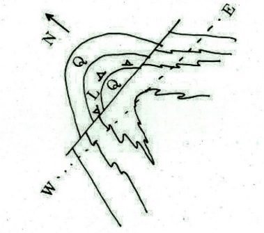
Q5. (a) The map pattern of alternate sequence of quartzite and limestone is given below. Interpret the structures in the given map and draw a cross-section along E-W line and plot the bedding (pole) in a free hand stereoplot.
(b) Write short notes on the following:
(i) Class 2 fold
(ii) Slaty cleavage
(iii) Crenulation cleavage
(iv) Boudin
(v) Dynamic recrystallisation
(c) Draw suitable figures to explain Fault Bend Fold and Fault Propagation Fold.
SECTION D (Attempt any one question)
Q6. (a) Discuss the types of plate boundaries and explain the driving
forces of plate motion related to mantle dynamics and gravity force.
(b) Describe the applications of palaeomagnetism in determining the
palaeoposition of India.
Q7. (a) Illustrate the layered structure of the Earth with emphasis on the
mineral composition, density and temperature.
(b) Write short notes on the following:
(i) Magnetic anomaly
(ii) Transform fault
(c) Discuss the evolution of ocean island chains with examples.
SECTION E (Attempt any one question)
Q8. (a) Give stratigraphic succession of Western and Eastern Dharwar
craton. Explain, how the Dharwar craton grades into southern granulitic terrane
through transition zone, based on lithology.
(b) Draw a profile across Himalayan orogen and show different
tectono-stratigraphy units in it. Explain each unit with respect to its
topography, lithology and age. Plot the following features in the profile : (i)
Blue schist rocks (ii) Dras volcanics (iii) Kiogars (iv) Paleozoics of the
Kashmir valley.
Q9. (a) Discuss stratigraphy, sedimentation and fossil content of Gondwana
sediments of India.
(b) Tabulate the litho-bio-chronostratigraphy of Kutch Basin.
(c) Write short notes on the following:
(i) Subathu Formation
(ii) Papagni Group
SECTION F (Attempt any one question)
Q10. (a) Elucidate the applications of Munier-Chalmas notation of the
dentition of pelecypods with neat diagrams.
(b) Enumerate the types of microfossils and discuss the significance of
organic-walled microfossils in biostratigraphy and hydrocarbon exploration.
Q11. (a) Explain the PETM event in geological record.
(b) Discuss the Siwalik vertebrate fauna and their stratigraphic distribution.
(c) Illustrate the Echinoid test with a sketch and comment on its ecology,
stratigraphic range and geological history.
Click Here to Download PDF
<< Go Back To Main Page
Courtesy: UPSC
