(IGP) IAS Pre: GS - Geography - World Geography General: Africa

World Geography General
Africa

Introduction

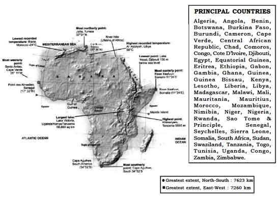
Area: 3,03,35,000 sq. km (20.4% of total area Madagascar and other islands of Africa)

Population : 778.5 million

Latitude : 37031'N to 34052'S Longitude : 25011'W to 51024'E

Size : Second largest continent after Asia and nine times the size of India.

Situation : Situated to the south of Europe and south west of Asia. It is bound by the Meditarranean Sea in the north, the Atlantic Ocean in the west and southwest, the Indian Ocean in the east and the Red Sea in the northeast. Africa belongs to all the four hemispheres and bulk of the continent lies in tropics. It is joined to Asia by the narrow isthmus of Suez and separated from Eurasia at three diffirent points (Strait of Gibraltar, Suez Canal and Strait of Bab-el-Mandeb). The only continent which is crossed by Tropic of Cancer, Equator and Tropic of Capricorn.
Africa is called as the “Dark Continent’ because the greater part of its vast interior remained little known to the outside world until the last century.

Important Seas / Ocean Channels around Africa:

Name Location African Countries Along the Sea
Mediterranean Sea
  • It separates Africa from Europe.
  • Region around are known for its
    distinct climate.
North of Africa Morocco, Algeria, Tunisia, Libya, Egypt.
Red Sea
  • It separates Africa from Asia.
North East of Africa Egypt, Sudan, Eritrea and Djibouti.
Indian Ocean East of Africa Somalia, Kenya, Tanzania, Mozambiquei
and South Africa
Atlantic ocean West of Africa Morocco, Western Sahara, Mauritania,
Senegal, Gambia, Guinea Bissau,
Guinea, Sierra Leone, and Liberia, Ivory
Coast, Ghana, Togo, Benin, Nigeria,
Camernoon, Equatorial Guniea, Gabon,
Congo, Zaire, Angola, Namibia, South
Africa.
Mozambique Channel East of Mozambique Mozambique (West) and Madagascar
(East).

Important Gulfs and Bays

Name Location
Gulf of Guinea South of Ivory coast, Ghana, Togo, Benin, Nigeria, Cameroon and Equatorial
Guinea in the Atlantic Ocean.
Walvis Bay West of Namibia, Atlantic Ocean
Maputo Bay South East of Mozambique, Indian Ocean.

Important Straits

Name Separates Connects
Strait of Gibraltar Europe from Africa Mediterranean Sea with Atlantic Ocean.
Strait of Bab-el-Mandeb Djibouti (Africa) from Yemen (Asia) Red Sea with Gulf of Aden.
Coasts of Africa Countries  
Grain Coast Sierra Leone and Liberia  
Ivory Coast Ivory Coast  
Gold Coast Ghana  
Slave Coast Togo, Benin and Nigeria.  

Important Lakes

Name Information
Lakes from South to North  
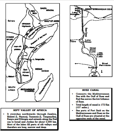
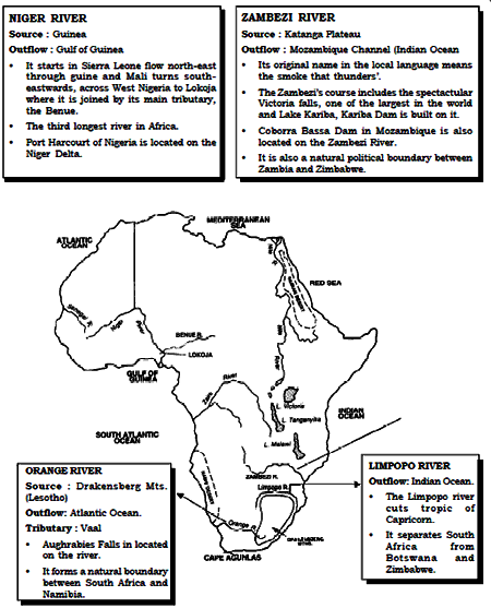
LakeKariba
  • Southernmost lake which is located on the Zambezi River in Zambia. One of the biggest man-made lake where
    commercial fishing is done.
  • Largest producer of hydroelectricity in Africa.
Lake Nayasa (Lake Malawi)
  • Rift valley lake, which lies along the Malawi, Mozambique, and Tanzania.
  • Third largest lake in Africa.
Lake Mweru
  • A small lake which lies along the border of Democratic Republic of Congo (Zaire) and Zambia.
Lake Tanganyika
  • Rift valley lake which lies along the Tanzania, Zaire and Zambia.
  • World’s second deepest lake (1435 m ) after Ozero, Baikal and also the second largest lake of Africa.
  • It lies 2500 m above sea level.
Lake Edward
  • Located between Uganda and Democratic Republic of Congo.
Lake Victoria

Area : 68,880 sq. km.
Max. depth : 80 m.

  • Largest lake of Africa which is located between Uganda, Keyna and Tanzania.
  • Source of White Nile River.
  • It does not lie in the rift valley.
  • A large lake through which equator pass.
  • World’s third largest lake after Caspian Sea and Lake Superior.
  • It contains numerous islands coral reefs.
Lake Turkana (Lak Rudolf)
  • Rift valley lake of Kenya
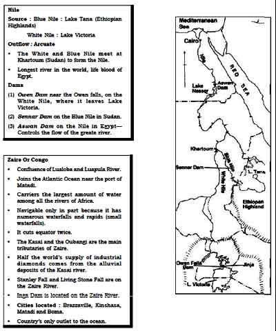
Lake Tana
  • Lake situated in the Ethiopian highlands.
  • Source of Blue Nile River.
Lake Nasser
  • Lake lies on the River Nile.
  • Man-made lake, which is located between Egypt and sudan.
Lake Chad
  • Largest lake (shallow fresh water lake) of Sahara in chad.
  • Actually an example of deflation hollow which is formed due to wind erosion.
  • A lake of inland drainage where the Chari River drains.
Lake Volta
  • One of the largest man-made lakes on the River Volta in Ghana
Lake Assal
  • Located in Djibouti.
  • The lowest point in Africa.

Important Rivers

Important Mountains and Plateaus:

Name Information
Atlas Mountains

Divided into five separate running to each other-

  1. High (Haut) Atlas Mts
  2. Anti-Atlas
  3. Middle Atlas
  4. Sahara Atlas
  5. Maritime Atlas
  • Highest peak- Jbel Toubkal (4165m) located in High Atlas Mountains.
  • Dominates in the rugged country of Morocco
  • These mountains sweep across the centre from north east to south-west and rising 2,750 m in the Middle Atlas to over 4,000 m in the High Atlas and to the south the Anti- Atlas (the uplifted edge of the Saharan platform) reaches 2,000 m.
  • An example of fold mountain.


Ethiopian Highlands

Highest peak : Ras Dashan (4,620 m) is the Africa’s third highest peak.

  • High plateau of volcanic origin.
  • The high plateau is split by the Great Rift vallyey along a north east-southwest line.
  • Source of the Blue Nite River.
Mt. Kenya (5,200 m)
  • Africa’s second highest peak, volcanic in origin.
Mt. Elgon (4,210 m)
  • Mighly peak of Kenya, lies on the Uganda border.
Mt. Kilimanjaro (5,895 m)
  • Also known as Mount Kibo.
  • It stands alone, not apart of mountain range.
  • Africa’s highest peak locatedin Tanzania.
  • An example of extinct volcanoes.
  • Coffee is grown on the slopes of Kilimanjaro.
  • Just 322 km from the equator, mountain peaks covered with perpetual snow throughout the year.
Drakensberg Scarpland
  • High escarpment in Southeast Africa caused by lava flow.
  • An example of continental plateau, formed due to epeirogenesis (continental building) movement.
  • From the escarpment rim, the land slopes inwards down to the Kalahari desert in the north.
Mount Rouwenzori (5,109 m)
  • Situated near the Lake Mobutu or Lake Albert in Zaire.
  • Known as the ‘The Mountains of the Moon’.
Mount Cameroon (4,070 m)
  • Only active volcanic mountain of Africa, dominates the coastline of Cameroon.
  • Known for iron ore deposits.
  • Wettest place in Africa along slopes of Mt. Cameroon.
Tibesti Massif (3,400 m)
  • Desert Mountains which is situated in the south east of Sahara in Norhtern Chad.
Ahaggar Massif
  • Desert mountains of Algeria.
Bomi and Nibas hills
  • The main hills of Liberia, known for Iron ore deposits.
Katanga Plateau
  • One of the largest copper and diamond producing region of Zaire.
Jos Plateau
  • The northern half of Nigeria consists of undulating Jos Plateau which rises to over 1,500 m in the centre.
  • Tin is the main mineral of this region.
Mount Sinai
  • Desert mountain of Egypt
Sahara desert
  • Lies between 150 top 300 N latitudes.
  • The largest stretch of desert, which is 5150 km from east to west and at least 1610 km in area.
  • Erg: Sandy desert of Sahara (9.1 sq. km) is undulating plain of sand, produced by wind deposition.
  • Hamada: Rocky desert of Sahara is bare rock surface formed by deflation.
  • Cities located in the desert fringe are Zinder (Niger), Timbuktu (Mali), Kano (Nigeria), and Kumasi (Ghana).
Libyan desert
  • Vast arid land of north-east of Africa in Libya.
  • Serir: Stony desert of Libya is covered with boulders, angular pebbles and gravels which have been produced by high diurnal temperature range.
Arabian desert
  • Arid region of North-East Egypt.
Nubian desert
  • It is an extension of Sahara which occupies a third of the Sudan’s territory in the north.
Namib desert
  • A narrow, dune-covered desert belt, runs 1,600 km along the entire Atlantic Sea board of Namibia.
Kalahari desert
  • Semi desert region of Botswana lies to the east of Namib desert.
  • Home of one of the Africa’s oldest races, the Kalahari Bushmen.

Click Here to Download full Chapter

Click Here for Africa MCQ  


© UPSCPORTAL.COM