(IGP) IAS Pre: GS - Geography - World Geography Physical: Atmosphere (Part -1)
World Geography Physical
Atmosphere (Part -1)
- Our planet is enveloped by a keep blanket of gases extending several kilometers above its surface.
- Like the lithosphere and hydrosphere, the atmosphere too is an integral part of a gigantic system i.e. earth.
- When compared with the radius of our planet, the atmosphere appears to be only a very thin layer of gases.
- However, because of the force of gravity, it is inseparable from the Earth.
Its Importance
- Atmosphere contains life-giving gases, like oxygen for man and animal, and carbon dioxide for plants.
- It also acts like a greenhouse and thus keeps the Earth warmer than it would otherwise be.
- The atmosphere, thus, acts like a blanket.
- It regulates the heat balance of the Earth and also protects us from the harmful ultraviolet radiation of the sun.
- The atmosphere serves as a storehouse for water vapour, which leads to precipitation and hence facilitates the hydrological cycles.
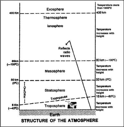
Structure of the Atmosphere
- The atmosphere has a layered structure, because of density stratification as a result of which lighter gases move up and denser ones settle down.
- The lowermost part of the atmosphere in which we live, and which is the theatre for which we live, and which is the theatre for almost all the weather phenomena is known as the troposphere.
- Troposphere literally means the region of ‘mixing’ and has been derived from the Greek word ‘tropos’, meaning mixing or turbulence.
- The height of the troposphere at the poles is about 8 km, while at the equator it is about 16 km. This is because there is greater heating at the equator.
- Above troposphere is the stratosphere, which is important primarily because of the presence of zone.
- This layer of calm and clear air is preferred for high-speed jet flights because of the absence of air pockets.
- Also, the near absence of water vapour in this layer prevents the formation of clouds, thus providing pilots with better visibility.
- Above stratosphere is mesosphere, which is more of a transitional layer.
Composition of Atmosphere
Oxygen 21.0%
Argan 0.93%
Carbon Dioxide 0.03%
Neon 0.0018%
In traces-Water vapour, Dust particles, Hellum, Ozone, Krypton, Xenon, Methane
- Above mesosphere lies the ionosphere, which has electrically conducting layers that help in radio communication.
- There are two important layers in the ionosphere viz. E Layer of Kennelly Heavy side layer that reflects the mediumradio waves, thus helping in short distance radio communication and F Layer or Appleton layer that reflects the short radio waves and helps in long distance radio communication.
- The outermost layer of the Earth’s atmosphere is known as the exosphere. It is so highly rarified a region that its boundary is not clear.
Heating and Cooling of the Atmosphere Insolation
- The word ‘insolation’ is an acronym for Incoming solar radiation, which is received at the Earth’s surface at the rate of 1.94 calories per square centimeter per minute.
-
Interstingly, the solar radiation falling on the Earth’s surface in one day would equal all the world’s industrial and domestic energy requirements for the next 100 years based on current rates of consumption.
- Energy transfers in the atmosphere take place in three ways: radiation, conduction and convection.
- The vast amount of energy coming to and leaving the Earth is through radiation.
- This, from the sun, is in the form of short waves.
-
Radiation from the Earth is called terrestrial radiation and it is in the form of long waves. The atmosphere is heated more by terrestrial radiation than the incoming solar radiation and this also explains why the atmosphere is heated fromthe ground up instead of vice versa, specially in the troposphere.
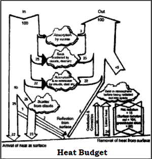
Heat Budget
- The average temperature of Earth remains rather constant. It has been possible because of the balance between the amount of incoming solar radiation and the amount of terrestrial radiation returned to space.
- This balance of incoming and outgoing radiation has been termed Earth’s heat budget.
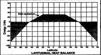
Latitudinal Heat Balance
- At latitudes below 40 degrees, more solar radiation is received than is lost to space by Earth.
- The opposite is true for higher latitude where more heat is lost than received.
- Although Earth as a whole maintains a balance between the incoming and outgoing radiation, its ratio is not uniform all over the Earth.
- The atmosphere and the oceans act as giant thermal engine that transfers heat from the tropics towards the poles.
- In this heat transfer, the air masses, winds and ocean currents play crucial rote.
- Most of the heat transfer takes place across the mid-latitudes hence; much of the stormy weather is associated with this region.
- Thus, the transfer of surplus energy from the lower latitudes to the deficit energy zone of the higher latitudes maintains an overall balance over the Earth’s surface.
Inversion of Temperature
- Occasionally the temperature in the lower layers of the air increases instead of decreasing with elevation.
- It occurs particularly on cold winter night, when the sky is clear, the air is very dry, and there is no wind.
- These conditions permit quick radiation of heat from the earth’s surface as well as from the lower layers of the atmosphere.
- The upper air which loses its heat less rapidly remains comparatively warm.
- Thus, there is reversal in the vertical distribution of temperature, which is known as the inversion of temperature.
- This phenomenon is specially observed in the intermontane valleys.
Temperature Anomaly
- Temperature varies even along the same parallel of latitude, land and water contrasts, prevailing winds and ocean currents.
- The difference between the mean temperature of any place and the mean temperature of its parallel is called the temperature anomaly or thermal anomaly.
- The anomaly is said to be negative when the temperature at a place is less than the expected temperature of the latitude.
- The anomaly is positive when the temperature at a place is more than the expected temperature of the latitude.
Atmosphere Pressure
- Air is an extremely compressible gas, and as result, atmospheric pressure varies considerably with height.
- Since the pressure will vary according to the weight of the air above it, the lowest layers of air are densest.
- The modern metric unit of pressure measurement is the millibar (mb), one millibar being equal to the pressure necessary to support 0.75 mm of the mercury column.
- The mean sea level pressure of the atmosphere is 1013.2 mb.
- Most of the atmospheric mass is concentrated in the layers:
I. Below5.6 km: 50% of atmospheric mass
II. Below16 km: 90% of atmospheric mass
III. Below32 km: 99% of atmospheric mass
The origin of pressure
- Air has weight and it therefore exerts pressure, called atmospheric pressure, on the earth’s surface.
- The pressure is not the same for all regions, nor is it always the same for any one region all the time.
- Atmospheric pressure is affected by altitude, by temperature, and by earth rotation.
Influence of altitude on pressure
- Air pressure at sea level is higher than it is at the top of a mountain.
- Air pressure increases when air descends. When it descends its volume decreases but the number of molecules in it remains the same.
- Similarly, when air rises, its volume increases and the outward pressure of its molecules is spread over a larger area, and its pressure decreases.
Influence of temperature on pressure
- The temperature of air rises when its pressure rises.
- The temperature of air falls when its pressure falls.
- The pressure of the air falls when its temperature rises.
- The pressure of the air rises when its temperature falls.
- Temperature: Low temperatures at the poles cause the air to contract- high pressure develops.
- High temperatures along the equator cause the air to expand- low pressure, called the doldrums lowpressure, develops.
Vertical distribution of pressure
- Air being a mixture of gases is highly compressible.
- Its density is greatest at the lower layers where is compressed under the mass of air above.
- As a result, the lower layers of the atmosphere have high pressure.
- In contrast, the higher layers are less compressed and hence, have low pressure.
- Air pressure always decreases with increase in altitude.
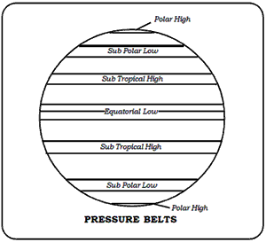
Horizontal distribution of pressure
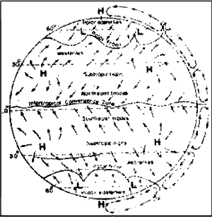
- It is the distribution of atmospheric pressure across the latitudes. Its main feature is its zonal character known as pressure belts which number seven.
- The leading function of the general circulation of atmospheric is to redistribute heat and moisture across Earth’s surface.
- Atmospheric circulation accounts for about 87% of this heat redistribution while oceanic circulation accounts for the remainder.
World pressure pattern in July
-
It is summer in the northern hemisphere with the sun overhead along the Tropical of Cancer on 21st June. The doldrums extend well into the northern hemisphere and link up with the low pressure areas over the Asian land mass and south west USA.
- The sub-tropical high pressure of the northern hemisphere exists as separate areas over the oceans. In the southern hemisphere (where it is winter) it is almost continuous around the earth.
- The temperature low pressure areas over the North Atlantic and North Pacific Oceans are poorly developed.
World pressure pattern in January
-
It is summer in the southern hemisphere with the sun overhead along the Tropical of Capricorn on 22nd December. The doldrums extend into the southern hemisphere and are particularly well developed over Australia and Central Africa.
- The sub-tropical high pressure of the southern hemisphere is no longer continuous.
- It forms separate areas over the oceans. In the northern hemisphere it is continuous, having linked up with the high pressure areas over the Asian and North American land masses.
- The temperate low pressure areas over the North Atlantic and Pacific Oceans are well developed.
Measurement of air pressure
-
Pressure varies with temperature and altitude and the instrument which measures pressure is called a barometer. There are three types of barometer: mercury barometer, aneroid barometer and barograph.
- Air pressure is usually measured in a unit of measurement called a millibar.
- The resulting temperature differences produce the global wind system.
- Horizontal movement of the air is called wind.
- It flows from areas of high pressure to those of low pressure.
- Since unequal heating of Earth’s surface is one of the main reasons for the pressure difference, solar radiation may be considered the ultimate driving force of winds.
- Winds are always named from the direction they blow.
- An east wind is one that blows fromeast to west and south-west wind is one that blows from the south-west.
Wind system
- Prevailing or Planetary winds blow throughout the year from one latitude to the other in response to the latitudinal differences in air pressure, for example, the trade winds and the westerly winds.
- Westerlies of the southern hemisphere are stronger and more constant in direction than those of the northern hemisphere because of the vast expanse of water.
- They are developed between 40º and 65º south latitudes. These latitudes are hence often called Roaring Forties, Furious Fifties and Shrieking Sixties dreaded terms for navigators.
- Periodic winds reverse their direction periodically with season. For example, monsoons, land and sea breeze and mountain and valley breeze.
- Local winds flow in comparatively small area and have special characteristics. A lot of them are found in the Mediterranean lands and their nomenclature derived from the regional language.
Local Winds
Besides major wind systems of the earth’s surface, there are certain types of winds, even though on a much smaller scale, which are produced by the topographical peculiarities or local temperature differences. Since these wind systems are generated by purely local factors and their zone of influence is quite limited, they are termed as local winds. They play an important role in the weather and climate of a particular locality.
Monsoon Winds of SE Asia
- The powerful control exerted by the great landmass of Asia on air temperatures and pressures extends to the surface and systems as well.
-
Development of a summer low and a winter high over Asia in middle latitude creates a seasonally alternating system of pressure gradients and with it a seasonally reversing set of surface winds which we call a monsoon system.
-
In summer, the low-pressure centre tends to develop in the southern part of the continent. This is low pressure associated with heating of the lower levels of the atmosphere; it does not extend high into the troposphere. Nevertheless pressure gradients at low levels are radially inward from sea to land, so that a cyclonic circulation forms.
- This is the summer monsoon, which in southern and eastern Asia is associated with the rainy season of the year.
Local Winds
| Names | Nature | Region |
| Fohn | Warm | Alps |
| Chinook (Snoweater) | Warm | Rockies |
| Kalbaisakhi | Warm | North India |
| Berg | Warm | S. Africa |
| Zonda | Warm | Andes |
| Loo | Warm | Indian Subcontinent |
| Santa Ana | Warm | Coastal Southern California |
| Southerly | Cold | New South Wales Burster |
| Khamsin | Warm | Egypt |
| Harmattan(Doctor) | Warm | Guinea Coast |
| Mistral | Cold | S E France |
| Samun | Warm | Iran |
- In winter, intense cooling produces the centre of higher pressure in the northerly part of the landmass.
-
An anti-cyclonic circulation is set up with surface winds blowing from continental interior towards the coast, In southern and eastern Asia, this winter monsoon is associated with a period of dry, cool weather.
Wind as an Energy Resource
- Wind power is an indirect form of solar energy that has been used for centuries.
- The windmill of the Low Countries (Belgium, Netherlands and Luxembourg) of Europe played a major role in pumping water from the polders as they were reclaimed from tidal land.
- Windmill was also used to grind grain in low, flat areas where streams could not be adapted to water power.
- The total supply of wind energy is enormous.
-
The World Meteorological Organization has estimated that the combined electricity generating wind power of favourable sites throughout the world comes to about 20million megawatts, a figure about 100 times greater than the total electrical generating capacity of the United States.
Latitudinal Shifting of Wind Belts
- When the sun shines vertically above the Tropic of Cancer, it is then summer solstice, and when it is vertical above the Tropic of Capricorn, it is winter solstice.
- With the shifting of the position of sun, the insolation belts make a corresponding shift.
- This results in north-south displacement of the temperature belts.
- Since pressure and wind belts are largely controlled by position of the sun, they are also displaced north and south with the apparent movement of the sun.
- Generally, winds are thought to be the prime factors in weather phenomena.
- An air mass is a large body of air where physical properties like temperature and moisture content are relatively uniform horizontally.
- An air mass extends over hundreds of kilometers and consists of several layers, each having homogenous conditions. Thus, it has a stratified structure.
- Most of the major weather changes in the middle and higher latitudes are a result of advance and interaction between the air masses.
- The entire primary and secondary circulations in the atmosphere are controlled by the air masses.
- However, the concept of air masses is more difficult to apply in low latitude regions, where air masses contrasts are less marked.
Upper Air Circulation
- In the mid-latitudes, high-speed winds known as jet streams blow from west to east in the upper troposphere near the tropopause, the interface between troposphere and stratosphere.
- Jet streams are narrow meandering bands of swift winds that are embedded in the prevailing westerlies and encircle the globe.
Cyclones
Cyclones Regions
Typhoons China Sea
Tropical cyclones Indian Ocean
Hurricanes Caribbean Sea
Tornadoes USA
Willy Willies Northern Australia
- Jet streams play an important role in the possible formation, steering or intensifying weather phenomena such as monsoons, cyclones, anticyclones and other weather conditions.
- They are also used by aviators if they have to fly in the direction of the flow of the jet streams.
Weather Disturbances
- Cyclones, hurricanes and typhoons, differing only in name, transfer energies equal to several megaton nuclear bombs, from the ocean to the atmosphere every year.
- Nearly 70 to 90 cyclonic systems develop all over the globe every year.
- The Carioles force, the deflecting force caused by the rotation of the Earth about its own axis, is maximum at the poles and progressively decreases to zero at the equator.
- It is this force that compels the surface winds to spiral towards the low pressure system.
- As Carioles force is negligible in the equatorial belt between latitudes 5º N and 5º S, Cyclonic systems do not develop in this region.
- Cyclonic systems do not develop or intensify all of sudden. They build up over a period of time.
- The topography and the intensity as well as frequency of cyclones that could strike a coast decide the vulnerability of the place.
- Tropical cyclones are the most destructive and violent type of storms.
-
Damages to life and property caused by them fall into three categories; (a) damages caused by high velocity winds, (b) damages caused by flooding, and (c) damages caused by a storm surge. • Torrential rains that occur in a hurricane inundate the low-lying areas, cause floods and landslides resulting in a great loss of life and property damage.
- According to many weather scientists, by far the greatest damage and loss of life and property from intense tropical cyclones are due to storm surges.
- The rise in sea level because of the passage of a hurricane is called the storm surge.
Moisture in the Atmosphere
- Although water-vapour content forms only a small proportion by volume of the atmosphere, it is the most important constituent of air in deciding weather and climate.
- Water may be present in the atmosphere in all the three forms.
Humidity
- The amount of water vapour in the air is called humidity.
- The humidity of the air depends upon the temperature, e.g. if the temperature rises then air can hold more water vapour.
- When air can hold no more water it is said to be saturated.
- The actual amount of water vapour in a given volume of air at a particular temperature is called the absolute humidity.
- The ratio between the absolute humidity of a given mass of air and the maximum amount of water vapour that it could hold at the same temperature is called the relative humidity.
- Changes in humidity account for production of precipitation.
To measure humidity
Two ordinary thermometers are used to measure the humidity, and they are the Stevenson Screen wet bulb thermometer and hygrometer.
Different Measures of Humidity
- Absolute Humidity is the weight of actual amount of water vapour present in a unit volume of air, expressed as grams per cubic metre of air.
- Specific Humidity is the weight of water vapour per unit weight of air, expressed as grams per kilogram of air.
-
Relative Humidity is the ratio of the air’s actual water vapour content to its water vapour capacity at a given temperature, expressed as percentage. Air containing moisture to its full capacity at a given temperature is said to be saturated (when relative humidity= 100%). The temperature at which saturation occurs is known as dew point.
Clouds
- A cloud is a mass of small water droplets or tiny ice crystals.
- Clouds form when moist air rises and cools.
- Heat from the sun turns, water in the oceans, rivers and moist soil, into water vapour.
- The water vapour expands as it rises and becomes cooler.
- Cool are cannot hold asmuchmoisture as warm air and soon reaches a saturation point.
- The water vapour condenses into tiny water droplets forming clouds.
- Their form, shape, height and movements tell us a great deal about the sky conditions and the likely weather.
- Formeteorological purpose, the amount of cloud cover in the sky is expressed in eights or oktas.
2/8 Quarter covered
4/8 Half covered
8/8 Completely overcast
Visibility Table
Haze > 2 km
Mist 1-2 km
Fog < 1 km
Smog Near zero visibility
- Clouds are classified according to their appearance, form and height. There are four groups.
A High clouds 6000 to 12000 m
B Middle clouds 2100 to 6000 m
C Low clouds below 2100 m
D Clouds of great 1500 to 9000 m vertical extent.
- The different types of cloud are given Latin names which are all combinations of the following words.
1. Cirrus means looking like a feather, it is used to describe the very high clouds.
2. Cumulus means looking like a heap. It is used to describe clouds which have flat bases and rounded tops. There are patches of blue sky between the clouds.
3. Stratus means lying in level sheets. It is used for layer-type clouds.
4. Nimbus means rain cloud.
5. Alto means high.
High clouds
- These clouds are 6000 to 12000 m above sea level.
- Cirrus: These are composed of small ice crystals; white, wispy, fibrous or feather-like in appearance; in bands or patches.
- Cirrocumulus. These are also composed of ice crystals but they are globular or rippled (like ripples in the sand on a sea shore) in appearance; forming a thin cloud.
- Cirrostratus: Looks like a thin white almost transparent sheet which causes the sun and moon to have ‘halos’.
Middle clouds
- Altocumulus: These are composed of water droplets in layers or patches, globular or bumpylooking with flattened bases arranged in lines or waves.
- Altostratus: Composed of water droplets; forming sheets of grey or watery-looking clouds, partly or totally covering the sky.
Low clouds
- Stratocumulus: Large globular masses; bumpy looking; soft and grey in appearance forming a pronounced regular and sometimes wavy pattern.
- Nimbostratus: Dark grey and rainy-looking dense and shapeless; often give continuous rain.
- Stratus: These clouds are low, grey and layered, almost fog-like in appearance; bring dull weather and often accompanied by drizzle.
Clouds of great vertical extent
- Cumulus: Rounds-topped and flat-based forming a whitish-grey globular mass; consists of individual cloud units.
-
Cumulonimbus: This is a special type of cumulous cloud of great vertical extent; white or black globular masses whose rounded tops often spread out in the form of an anvil; summits rise like towers and mountains; often indicate convectional rain, lightening and thunder.
Precipitation
- On the basis of its origin, precipitation may be classified into three main types- convectional, orographic, and cyclonic or frontal.
A. Convectional Precipitation
- It is caused by convectional ascent of warmand humid air to great heights.
- It is heavy but highly localized, occurs mostly during the days and is associated with minimum amount of cloudiness.

Click Here to Download full Chapter
Click Here for Atmosphere MCQ
© UPSCPORTAL.COM
