(IGP) IAS Pre: GS - Geography - World Geography Physical: Lithosphere (Part -1)
World Geography Physical
Lithosphere (Part -1)
Our Planet Earth
- Earth, the home to mzankind, is a unique member of the solar family.
-
The fifth biggest planet in the solar system, its uniqueness lies in its habitabilitzz vertically overhead at the equator on two days each year, i.e. on March 21st and September 23rd. These days are called equinoxes meaning ‘equal nights’ because on these two days all places on Earth have equal days and nights.
-
After the March equinox, the sun appears to move northwards and is vertically overhead at the Tropic of Cancer on June 21st. Thus is known as the summer solstice, when the northern hemisphere will have its longest day and shortest night.
- By December 22nd, the sun is overhead at the Tropic of Capricorn. This is the winter solstice when the southern hemisphere will have its longest day and shortest night.
Movement of Earth
- The earth moves in space in two distinct ways. It rotates on its own axis from west to east once in every 24 hours causing day and night.
- It also revolves round the sun in an orbit once in every 365 ¼ days causing the seasons and the year.
- The earth revolves round the sun in an elliptical orbit at a speed of 18.5 miles per second.
- A normal year is taken to be 365 days, and an extra day is added every four years as a Leap Year because 1/4th day of every year becomes 1 day.
Latitudes and Longitudes
- Latitude is the angular distance of a point on the Earth’s surface, measured in degrees from the centre of the Earth.
- Longitude is the angular distance, measured in degrees along the equator, east or west of the Prime Meridian (the meridian that passes through Greenwich near London).
- This is the meridian from which all other meridians radiate eastwards and westwards up to 180º.
- Longitudes are not used for calculating distances, since there is so much difference in the length of degrees of longitude outside the tropics.
- But they have one very important function-they help in determining local time in relation to Greenwich Mean Time (GMT).
Standard Time and Time Zones
- Most countries adopt their standard time from the central meridian of their countries.
- The whole world has been divided into 24 Standard Time Zones.
- Each zone, therefore, is separated by 15º
| Whole Earth | Earth’s Crust | ||
| Elements | Percentage | Elements | Percentage |
| Iron | 35 | Oxygen | 46 |
| Oxygen | 30 | Silicon | 28 |
| Silicon | 15 | Aluminum | 8 |
| Magnesium | 13 | Iron | 6 |
| Nickel | 24 | Magnesium | 4 |
| Sulphur | 1.9 | Calcium | 2.4 |
| Calcium | 1.1 | Potassium | 2.1 |
| Aluminum | 1.1 | Sodium | 2.1 |
| Others | 1.0 | Others | 1.0 |
longitudes or by one hour.
- Larger countries like USA, Canada and Russia having greater east-west stretch have to adopt several time zones.
- Both USA and Canada mainland have five time zones each- the Atlantic, Eastern, Central, Mountain and Pacific.
- Russia has 11 time zones.
- Interestingly, despite a considerable east-west stretch, India has only one time Zone.
Earth’s position with respect to Moon
- Apogee: The period of the farthest distance between the moon and the earth (407,000km) is called apogee.
- Perigee: The period of the nearest distance between the moon and the earth (356,000 km) is called perigee.
Earth’s position with respect to Sun
- Perihelion: The period of the nearest distance between the earth and the sun (147 million kilometer) is perihelion. It happens on January 3.
- Aphelion: The period of the farthest distance between the earth and the sun (152 million kilometers) is called aphelion. It happens on July 4.
International Date Line
- A traveler going eastwards gains time from Greenwich until he reaches 180º E meridians, where he will be 12 hours ahead of GMT.
- Similarly going westwards, he loses 12 hours till he reaches 180ºW.
-
There s, thus, a total difference of 24 hours or a whole day between the two sides of the 180º meridian. This is the International Date Line where the date changes by exactly one day when it is crossed.
-
The International Date Line in the mid-Pacific curves from the normal 180º meridian at the Bering Strait, Fiji, Tonga and other island to prevent confusion of day and date in some of the island groups that are cut through by the meridian.
Earth’s Interior
-
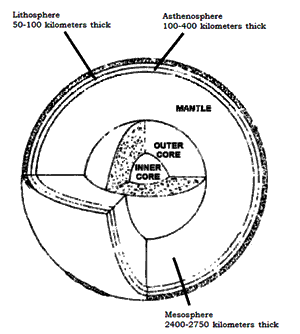
Temperature inside the Earth increases with depth.
-
Experiments have confirmed that the temperature increases at the rate of 1ºC for every 32 metres.
-
With this rate of increase all the matter at the Core should have been in a molten state, but since the pressure at such great depths is also very high, the melting point is higher than the prevalent temperature and the inner Core is in a solid state.
-
In the outer Core, however, the pressure is lesser and the matter is in a liquid state.
-
The Core and the Mantle are separated by the Guttenberg discontinuity, while the Mohorovicic discontinuity separates the Mantle from the Crust.
-
Besides, the upper granitic and the lower basaltic layers of the crust are separated by a seismically determinable boundary called the Conrad discontinuity.
-
The uppermost portion of the mantle on which the crust rests, is rigid.
-
The crust and this solid uppermost mantle are together called lithosphere, the sphere of rocks.
-
Below the lithosphere, the upper mantle becomes so hot that it resembles hot plastic.
-
This soft plastic layer in the upper mantle is called the asthenosphere.
-
The hot plastic character of the asthenosphere and the convective beat cells facilitate the movement of lithospheic plates overlying this layer.
Earth’s Magnetic Field
- The Earth’s magnetic poles do not coincide exactly with the geographic poles.
- Earth’s magnetic field reverses polarity; that is, the north magnetic pole becomes the south magnetic pole and vice versa.
- However, it is not known exactly how the Earth’s magnetic field is produced.
Plate Tectonics
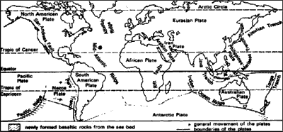
- The theory of Plate Tectonics states that the lithosphere consists of several individual segments called plates.
- About twenty such plates have been identified.
- Of these, the largest is the Pacific plate while the Juan de Fuca plate, of the western coast of North America, is the smallest.
- Most of the Earth’s seismic activity, volcanism and mountain building occur along these dynamic margins.
- Depending on the type of movement, plate margins are of three types-Divergent, Convergent and Transform fault boundaries.
- When plates move apart with the upwelling of material from the mantle, a divergent plate boundary results.
-
The conspicuous mid-Atlantic Ridge system wherefrom the Atlantic Ocean is widening: the Red Sea that is driving a wedge between Africa and the Arabian Peninsula and the Great Rift Valley of Africa are examples of such divergent plate boundaries.
- A convergent plate boundary is one where two plates collide, one plate bending downward and sub ducting below the other.
Continental Drift Theory
- F B Taylor postulated his concept of ‘horizontal displacement of the continents’ in the year of 1908 to explain the problems of the origin of the folded mountains of tertiary period.
- Alfred Wagener propounded his concept on continental drift in the year 1912 which is also known as displacement hypothesis. It was propounded to explain the global climatic changes.
Sea Floor spreading
- The concept of sea floor spreading was first propounded by professor Hary Hess in the year 1960.
- Collisions can occur between two oceanic plates, one oceanic and one continental plate or two continental plates.
- A deep-ocean trench is formed adjacent to the zone of subduction while the upwelling magma generated by a complex process of melting of the subducting crust cause explosive volcanic eruptions.
- The volcanic portions of the Andes Mountains have been formed by the subduction of the Nazca plate below the continent of South America.
- The mechanism is similar in the case of oceanocean convergence except that the chain of volcanoes forms on the ocean floor rather than on land. Island arcs like the Aleutian, Mariana and Tonga exemplify such convergence.Oceanic trenches viz. the Aleutian, Mariana and Tonga parallel such Island arcs.
- The collision of the Indian plate against the Eurasian plate, leading to the formation of the spectacular Himalayas is an example of continent-continent convergence.
- Prior to the collision, the landmasses were separated by oceanic crust which in the case of the Himalayas was the Tethya Sea.
- Youngest fold mountain of the world continues to rise even today.
- The third type of plate boundary is the transform fault, which is located where plates slide past one another without the creation or destruction of crust.
- Transform faults provide the means by which the oceanic crust created at the divergent plate margins can be transported to its site of destruction, the deep-ocean trenches.
- These faults are so called because the relative motion of the plates can be ‘transformed’ along them.
- The relative motion of the North American plate occurs along the famous San Andreas Fault, which is one of the most seismically active faults of the world.
Volcanism & Earthquakes
Volcanism
- It is the eruption of molten rock at the earth’s surface, often accompanied by rock fragments and explosive gases.
- Volcanism and the degassing of Earth gave Earth its atmosphere.
- Lava, dust and pyroclasts spewed out from volcanoes cause widespread devastation.
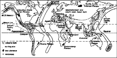
- Greatest volume of volcanic matter is produced along the oceanic ridge systems that are essentially divergent plate boundaries.
- Such volcanic activity had led to the sudden formation of the Surtsey Island, south of Iceland, in 1963.
- The ‘Ring of Fire’, which is the most active volcanic belt bordering the Pacific Ocean, is associated with subduction plate boundaries,
- The numerous volcanoes dotting the sea off Philippines, Japan, the Aleutian Islands and the volcanoes of the Andes mountains, are all examples of subduction zone volcanism.
- Volcanoes may also occur within a rigid plate, but the processes that lead to such in-plate vulcanism are difficult to explain.
- The volcanic Islands of Hawaii in the mid- Pacific and the famous hot water geysers of the Yellowstone region of North America are examples of such in-plate volcanoes.
Distribution of volcanic activity
- Most volcanism not associated with seafloor spreading is related to subduction zones and s concentrated at convergent plate boundaries.
- But some volcanic activities are associated neither with mid-oceanic ridges nor with subduction zones.
- These are regions of local magma tic extrusions, which are popularly known as the hotspots.
- The island of Hawaii, for example, lies in an archipelago in the middle of the Pacific.
- On the African Plate, where West Africa and Equatorial Africa meet (at Africa’s so-called “armpit”), lies Mt. Cameroon, another active volcano far from spreading ridges and subduction zones.
Active Volcanoes
- Mt. Etna (Mediterranean Sea)
- Stromboli (Mediterranean Sea)
- Pinatubo (Phillippines)
- Mayon (Phillippines)
- Cotapaxi
- Shasta
- Rainier
- Kilavea
- Volcanoes have been traditionally differentiated into active dormant and extinct.
- An active volcano is one that has erupted in recorded history, like Barren Islands in India and Mt. Stromboli in Italy.
- A dormant volcano has not been seen to erupt, but it shows evidence of recent activity, like Mt. Kilimanjaro.
- When a volcano shows no sign of life and exhibits evidence of long-term weathering and erosion, it is tentatively identified as extinct.
- Interestingly, there is no clear cut definition of an extinct or a dormant volcano.
Earthquakes
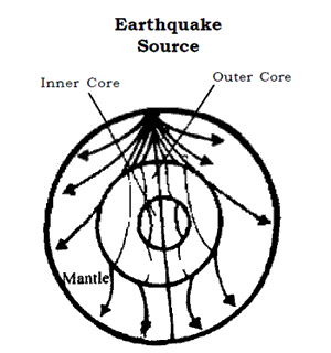
- An earthquake is basically the vibration of Earth produced by the rapid release of energy.
- This energy radiates in all directions from the source, focus, in the form of waves.
- The waves are very much analogous to those produced when a stone is dropped into a calm pond.
- Seismic sensors, called seismographs located throughout the world can record the event.
- It is estimated that over 30,000 earthquakes, strong enough to be felt, occur worldwide annually.
- Fortunately most of these are minor tremors and do very little damage and only about 75 significant earthquakes take place each year.
- The intensity of an earthquake and the destruction it causes are greater over softer soil regions, for example on alluvial soils, than on more rocky areas.
- Sometimes, the tremendous energy released by atomic explosions or by volcanic eruptions can also produce earthquakes, but these events are usually too weak and infrequent.
- The Himalayas, making the great mountain wall of the north, also happen to form the northern margin of the Indian plate and hence are marked by frequent and severe earthquakes.
- Seismicity may also occur away from such regions. Such seismic activities, located within the plates away from the plate margins, are called in-plate, seismicity.
- They are generally confined to the weaker zones of the earth’s crust.
- These weaker zones are represented by faults or fractures within the earth’s crust and are generally less intense than the ones found near the plate margins.
- One such zone of in-plate seismicity is the Narmada-Son lineament, cutting across the northern plane.
- The earthquake of January 26, 2001 which flattened parts of Gujarat was also caused by the growing ‘in-plate stress’ in the region.
- In fact, the whole Kutch is a fault, Bhuj, which bore the brunt of the natures, fury, lies close to the Allah bund fault.
- Hence, in-plate seismically is due to the reactivation of concealed shields (stable parts of the Earth) and release of energy.
Earthquake Waves
- Earthquakes generate pulses of energy called seismic waves that can pass through the entire Earth. Three major divisions of seismic waves have been recognized:
- Primary (P)Waves of short wavelength and high frequency are longitudinal waves which travel not only through the solid crust and mantle but also through the liquid part of the earth’s core.
- Secondary (S) Waves, of short wavelength and high frequency, are transverse waves which travel through all the solid parts of the Earth but not the liquid part of the core.
- Long (L) Waves, of long wavelength and low frequency, are confined to the skin of the earth’s crust, thereby, causing most of the earthquakes structural damage.
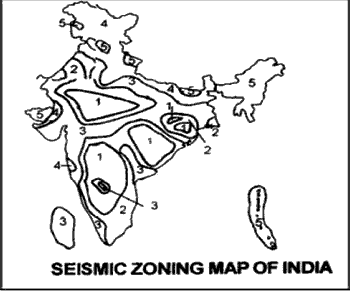
Seismic Zones of India
- Based on the intensities of earthquakes recorded on the Modified Mercalli scale, India is divided into five seismic zones.
Zone 1 Intensity V or below
Zone 2 Intensity VI
Zone 3 Intensity VII
Zone 4 Intensity VIII
Zone 5 Intensity IX and above - ‘Zone 5’ covers areas with a probable magnitude of 8 or more on the Richter scale.
- Zone I is the least seismic prone zone with magnitude of up to 4.9 on the Richter scale.
- Delhi falls in ‘Zone 4’ and is prone to earthquakes of magnitude between 7 and 7.9 on the Richter scale.
- The Rann of Kutch, the entire Northeast, the Andamans, certain parts of Jammu and a good part of Uttaranchal come under ‘Zone 5’.
Rocks and Minerals
- Rocks are made up of individual substances, which are called minerals found mostly in a solid state.
- Each mineral usually contains two or more simple substances called elements of which the whole earth is made.
- Out of about 2,000 different minerals, only twelve are common all over the earth.
- These twelve minerals are called the rock formers.
- The common minerals are formed of eight most abundant elements in nature.
- Out of these, silicates carbonates and oxides make up a large group of them.
- As many as 87 per cent of the minerals in earth’s crust are silicates.
- Quartz, for example, has two elements, silicon and oxygen, united together form a compound known as carbonate of lime.
Classification of Rocks
On the basis of the mode of formation, rocks are usually classified into three major types:
1. Igneous Rocks
- Igneous rocks are parents of all other rocks and are also known as primary rocks.
- They have been forming since earth began and are still formed in regions of volcanic activity.
- Extrusive igneous rock is the name given to magma eruption and solidifying after escape of gases as lava on reaching the surface of earth.
- This variety is also named as a volcanic rock.
- As lava cools down rapidly on coming out of the earth’s hot interior, the mineral crystals of extrusive igneous rocks change their structure and are very small, making them looks finegrained.
- A virtual absence of grains as in obsidian gives them a glassy appearance.
- Basalt is a typical example of extrusive type, covering 500,000 sq km of Peninsular India in its north-western part.
- These are Deccan Traps forming flat-topped hills at present.
- The basaltic material is used for building roads and yields a fertile black soil locally known as regur on its weathering.
- The intrusive igneous rock is formed by solidification of magma at moderate depths beneath the earth’s surface.
- The cooling is obviously slow because of the great heat at these depths and the crystals formed are large.
- The granite and the dolerite are the most common examples of such rocks.
- For this reason, granite is coarse-grained unlike the fine-grained basalt.
-
On the other hand, when solidification of magma occurs at great depths below the earth’s surface, the rate of cooling is much slower. As a result of this slow cooling, very large-sized crystals are formed in such rocks.
- These deep-stead intrusion are known as plutonic rocks.
- A highly coarse-grained granite is a typical example of plutonic rock.
- The granite of various colours-grey, red, pink or white is found on the Deccan Plateau in south India, in Madhya Pradesh, Chotanagpur, Rajasthan and in parts of the Himalaya.
- All igneous rocks are of magmatic origin and each intrusive type has an extrusive equivalent.
- They are massive having no layers, hard, compact, free of fossils and dark as basalt or light-coloured as granite depending upon greater or lesser amount of silica present in them.
- Those with a high proportion of silicon are said to be acid and others with a high proportion of basic oxides are denser and darker in appearance.
- These are crystalline rocks because each has crystals formed as a result of the process of crystallization for a longer or shorter period.
- Since magma is the chief source of metal ores, many of them are associated with igneous rocks.
Igneous rock bodies
- The intrusive igneous rock bodies include batholiths, stocks, laccoliths, sills and dykes.
- As the loss of heat is much slower inside the earth, the crystals grow larger during a prolonged process of crystallization.
- The extrusive igneous rock bodies formvolcanic mountains or volcanic plateaus within areas of mountain building and on the floor of ocean.
-
Batholiths are the largest intrusive igneous rock bodies. They may be 50 to 80 km across and hundreds of kilometers in length. They are so thick that their bottoms are not visible. We see them on the surface only when large amount of surface rock has been carried away. Their upper surface is irregular and dome shaped. The batholiths are great granite masses forming the cores of world’s mountain systems. Batholiths covering smaller areas are called stocks having somewhat rounded form and same general characteristics.
-
The Laccoliths are other huge masses of igneous rocks that have been formed between horizontal or slightly tilted layers of sedimentary rocks nearer the earth’s surface. The dome shaped masses ofmagma due to rapid movement upwards appear in the form of a mushroom or a loaf of bread.
-
The Dykes are near vertical formations, from a few metres to kilometers in length and from a few centiments to hundreds of metres in thickness. They come into existence when liquid material passes through cracks in the country rocks and gets hardened into a rock. They are not easily eroded rock is eroded.
-
Sometimes, magma trying to reach the surface squeezes between two rock layers and solidifies into a thin sheet in horizontal position parallel to the layres of already existing rocks. Such an intrusion is termed as a Sill.
2. Sedimentary Rock
- Although three-fourths of the earth’s surface is covered with sedimentary rocks, they make up only about 5 per cent of the volume of the earth’s crust.
-
Some sediments are of sand, some of clay and others are of different bits of rocks making pebbles or gravel. All sediments of one or the other type are carried by running water, wind or ice. These are left buried layer by layer at favourable sites, mostly settling down along silent water of a stream, a lake or sheltered parts of sea and its beaches. The sediments get sorted by the transporting agents like running water, winds, waves; the larger and heavier particles being deposited first after moving for a relatively short, distance. The smaller and finer particles are carried far away. Butmost of the material transported bymoving ice are not sorted out and are all dropped together when the ice melts.
- As sedimentation is favoured by water, most of the sedimentary rocks have been formed under water.
- The loess is one example of fine sand carried by wind and deposited as wind-borne sedimentary rock as in north-western China and Indian subcontinent.
- An unsorted mixture of clay and boulders known as boulder clay or ‘till’ is an example of ice-deposited sedimentary rock as in plains of northern Europe.
- Very often, loose and unconsolidated rock materials such as sand and clay, in course of time, get converted into hard and compact rocks such as sandstone and shale, respectively.
- They get hardened by compaction, i.e., by the pressure of some overlying material.
- While sand and clay generally turns into compact rocks by pressure, conglomerate and breccias are the examples of sedimentary rocks formed because of the process of cementation.
- The conglomerate is a collection of round pebbles taken from a sea shore or a riverbed mixed and bound together by some cementing stuff.
- The pebbles in the case of breccias are angular fragments indicating the work of an agent other than running water or moving ice.
- The organic matter derived from plant or animal remains is also the raw material for the formation of sedimentary rocks in course of time.
- Two well-known examples of sedimentary rocks of organic origin are coal and the limestone.
- The peat and lignite (brown coal) is the first stage of coal having below 45 per cent carbon and bituminous variety is the next stage with 60-70 per cent carbon.
- Likewise, the limestone is composed of shells and skeletons of dead marine animals.
- The lime shells of such organisms are cemented into limestone sedimentary rock of organic origin.
- The tiny organisms like corals and algae derive calcium carbonate from the sea water. Such are the reefs built from the skeletons of dead corals once living in tropical seas.
- The rock salt, gypsum and nitre like saltpeter are examples of such chemically formed sedimentary rocks as a result of evaporation of substances held in solution by water.
- All sedimentary rocks are layered, lying in horizontal beds.
- If their position is disturbed after the deposition, the beds are slightly inclined.
- As sediments are usually deposited in distinct layers or strata, these rocks are termed as stratified rocks.
- Most of them have ripple marks left by water.
- They have fossils embedded into their layers.
- They are in the form of prints of leaves, insects or soft bovine animals and pieces of bones, shells or some hard parts of old living beings.
- The large variety of sedimentary rocks are distinguished by the origin of sediments, and place of deposition and nature of cementing material, although they retain their common characteristics.
- The minerals of economic value are less in sedimentary rocks. But these are the source of hematite iron ore, phosphates, a number of building stones, coal and materials for making cement.
- Petroleum formed by the decay of tiny marine organisms also occurs in the muds of sedimentary rocks.
-
The decomposition of surface rocks under tropical conditions gives us the secondary ores of bauxite, manganese and deposits like tin derived from other rocks but found in gravels and sands carried by water.
- Sedimentary rocks also yield some of the rich soils.
- In the Indian sub-continent, the alluvial deposits in the Indo-Gangetic plain is of sedimentary accumulation. Clay and loam of different kinds occur in this plain.
- The great Vindhyan highland in central India consists of sandstones, shales and limestone’s.
- The significant coal, as a source of power and as an industrial fuel, occurs in the river basins of the Damodar, Mahanadi and Godavari in Gondwana sedimentary deposits.
- Assam and Gujarat are the chief petroleum producing states in India.
- But potential areas of new production are under exploration in sub-Himalayan zone and riverdeltas of the Ganga and Kaveri.
- The suitable structure in the oceanic sedimentary rocks to the west Bombay have started yielding petroleum.
- The prospects of new oil deposits exists in Rann of Kachch, the Gulf of Cambay and the continental shelf off the Andhra coast.
- Although derived from pre-existing rocks, it is interesting to note that some sedimentary rocks are older than either igneous of the metamorphic rocks as found in Greenland in 1973.
3. Metamorphic Rocks
- In Greek language, the word ‘metamorphic’ means ‘change of form’.
- These rocks are formed under conditions similar to those producing igneous rocks.
- The change takes place while the rock is in a solid or a plastic statemostly at depths of about 12-16 km below the surface.
- The process of metamorphism takes place at depths under the pressure of overlying rocks or as a result of contact with a hot igneous material.
- The formation of metamorphic rocks under the stress of pressure is known as dynamic metamorphism.
- In this case, granite is converted into gneiss; clay and shale are transformed into schist at great depths of the earth’s crust.
Important Metamorphic rocks
Basic rocks Metamorphosed
Limestones Marbles
Sandstones Quartzites
Shales/Clays Slates/Schist
Granites Gneisses
Gabbro Serpentine
Amphibolites Basic granulites
Basaltic rocks Eclogite - In India, both are commonly found over large parts of South India and in some parts of Assam, West Bengal, Bihar, Orissa, Madhya Pradesh and Rajasthan.
- They are also found in the Himalayas.
- Gneiss is largely used as a building stone and statues in the regions of is occurrence.
-
The change of form or re-crystallization of minerals of sedimentary and igneous rocks under the influence of high temperatures prevailing within the earth’s crust is known as the process of thermal or contact metamorphism.
- As a result of this type of metamorphism sandstone changes into quartzite; clay and shale are transformed into slate.
- The coal turns into anthracite and graphite with over 90 per cent carbon.
- Marble becomes a metamorphic rock equivalent of sedimentary limestone.
- Slate may further change into phyllite under temperatures ranging from 150ºC to 200ºC.
- The quartzite rock is one of the most resistant to weathering, forming mountains and ridges. It is used in glass making.
- The metamorphic rocks are recognized by their great hardness, closely banded structures and interlocking of crystals.
Classification of Landforms
- There are three major landforms- mountains, plateaus and plains.
Mountains
- An uplifted portion of the earth’s surface is called a hill or a mountain.
- In our country, a mountain is differentiated from a hill, when its summit or top rises to more than 900 metres above the base.
- Those with less than this elevation are called hills.
- On the basis of their origin or mode of formation, the mountains are classified as structural or tectonic, residual or dissected and volcanic.
Structural Mountains
- All great mountain systems of the earth are of this type.
- Such systems are hundreds of kilometers wide and thousands of kilometers long.
- Many of them lie near or parallel to continental coastlines.
- Both the fold and the Block Mountains are included in this type.
1. Fold Mountains
- The major mountains of the present day including the Alps in Europe, the Rockies of North America, the Andes of South America and the Himalayas of Asia are structural fold mountains.
- The granitic core of such mountains is surrounded by metamorphic rocks-merging with sedimentary layers along the margins.
- The phenomenon of folding and faulting ismost complex in the central areas of these mountains.
- These young fold mountains are still rising under the influence of the earth’s tectonic forces.
- They are known for variety of rock structures, deep gorges and the high pyramidal peaks.
- The Urals, the Appalachians, the Tien Shan and the Nan Shan were formed during an earlier mountain-building period.
- The highlands of Scotland and Norway and the Sayan and Stanovoy mountains in Russia are of still earlier period.
- The Aravallis are considered to be one of the oldest mountains on the earth.
2. Block Mountains
- These mountains are formed when great blocks of the earth’s crust may be raised or lowered during the late stages of mountainbuilding.
- During the uplift of structural mountains, sometimes magma flows upward into the crust.
- On its cooling and hardening beneath the surface, it contracts and the overlying rocks may crack into large blocksmoving up or down.
- An intense folding of rocks is generally followed by faulting of strata due to horizontal force of tension.
- The land between the two parallel faults, either rises forming block mountains or horsts, or subsides into a depression termed as a rift valley or graben.
- An old fold mountain may also be left as block mountains due to continuous denudation.
- These mountains have flat tops, steep fault scarps and the subsided portions between parallel faults are flat-bottomed.
- Then Vosges in France, Black forest mountains in Germany and Salt Range in Pakistan are cited as typical examples of block mountains.
- River Rhine in Europe flows through a rift valley.
- The great rift valley of the world runs for about 6,000 kilometres from East Africa to Syria through the Red Sea.
3. Volcanic Mountains
- As these are formed by the accumulation of volcanic material, they are also known as mountains of accumulation.
- The matter is thrown out and deposited around the crater to form a mountain.
- If the lava is thin and basic in its composition, it spreads a long distance forming a flatter cone of gentler slope and of low elevation.
- If it is thick and of acid composition, a small volcanic cone sharply pointing out is the result.
- Sometimes lava is thrown out along with ash and cinders. Such a volcanic cone is termed as ash and cinder cone.
- Mount Mauna Loa in Hawai islands is an example of the former type.
- Mt. Fuji Yoma of Japan andMt. Popa in Central Myanmar are examples of the latter one.
4. Residual or Dissected Mountains.
- They owe their present from due to erosion by different agencies.
- That is why they are also known as relict mountains or mountains of circumdenudation.
- They have been worn down from previously existing elevated regions.
- Hills like the Nilgiris, the Parasnath, the Girnar and Rajmahal in India are examples of this type.
- But Nilgiris got their present height as a result of subsequent uplift.
- According to some authorities, all mountains of the Peninsula with the exception of the Aravallis are relict mountains.
Plateaus
- A plateau is an elevated area generally in contrast to the nearby areas.
- It has a large area on its top unlike a mountain and has an extensively even or undulating surface.
- A steep cliff is usually marked along the side of a plateau away from the mountains except in the case of one surrounded by high mountains. It is along this slope that uplift takes place.
- The rocks of the plateau are layered with sandstones, shale’s and limestones.
- But an inclined or a tilted strata may also become flat through continuous wearing down.
- The great Deccan Plateau with its slope towards east is a tilted plateau in our country.
- Very often, rivers and streams cut out deep valleys and canyons in a plateau region.
Types of Plateau
- Intermountain plateau: Tibetan plateau, Bolivian plateau, Peru plateau, Columbian plateau, Mexican plateau, Iranian plateau, Anatolian plateau etc.
- Piedmont plateau: Appalachian Piedmont plateau, Patagonian plateau etc.
- Continental plateau: Deccan plateau of India, Ranchi plateau, Shillong plateau, Columbian plateau (USA), Mexican plateau, Tibetan plateau etc.
- Coastal plateau: Coromandal Coastal upland of India.
- Dome-shaped plateau: Chotanagpur plateau, (in Jharkhand)
- Dissected plateau: Deccan plateau of India.
- Step-like plateau: Kaimur plateau consisting of (from west to east, height decreases eastward) Panna plateau, Bhander plateau, Rewa plateau and Rohtas plateau.
- Flat-topped plateau: Tibet plateau, Bhander plateau (MP), Rewa plateau etc.
- Rejuvenated peneplain plateau: Missouri plateau of USA, Patlands of Ranchi and Palamau (Jharkhand).
- It changes its smooth topography into a dissected plateau.
- It changes its smooth topography into a dissected plateau.
- The plateaus are of three types on the basis of their situation (i) intermontane, (ii) continental, (iii) piedmont plateaus and (iv) Lava plateaus.
Intermontane Plateaus
- The plateaus which are partly or fully enclosed by mountain are known as intermontane plateaus.
- The highest and extensive plateaus of the world, such as Tibet, Bolivia and Mexico are of this category.
- These are the results of the mountain-building process which was accompanied by a vertical uplift of the adjoining enclosed lands.
Piedmont Plateaus
- Situated at the foot of mountain, they are bounded on the opposite side by a plain or an ocean.
- The plateau of Malwa in India, those of Patagonia in Argentina and the Appalachian n United States are some of the examples.
- These are also called the plateaus of denudation because areas which were formerly. high have now been reduced in elevation by various agents of erosion.

Click Here to Download full Chapter
Click Here for Lithosphere MCQ
© UPSCPORTAL.COM
