(IGP) IAS Pre: GS - Geography - World Geography Physical: Lithosphere (Part -2)
World Geography Physical
Lithosphere (Part -2)
Continental Plateaus
- They rise abruptly from the lowlands or from the sea.
- They are the result of a continental uplift producing large tablelands like the plateaus of Brazil, South Africa, West Australia, Chotanagpur and Shillong. Their heights vary from 600-1,500 metres.
- Sometimes a plain or a low-lying area is vertically uplifted and gives rise to a plateau.
- In India, plateaus of Kaimur, Rohtas, Ranchi and Karnataka are of this type.
- The Potwar plateau of Pakistan also falls in this category.
Lava Plateaus
- When lava spreads out to cover the preexisting land surface, a lava plateau is formed which is also called a plateau of accumulation.
- The horizontal sheets of lava flow have trapped the original topography varying in depth from 1,200-1,500 metres over large parts of Maharashtra and the adjoining areas in Deccan.
- The Snake River plateau in north-west United States, Antrim plateau of Northern Ireland are also good examples of such volcanic plateaus.
Plains
- A relatively flat and a low-lying land surface with least difference between its highest and lowest points is called a plain.
- The plains are usually lowlands.
- Some of them may be smooth, while others are slightly rolling.
- A plain may be as low as 30 metres to the east of Mississippi river near the Appalachian range and as high as 1,500 metres above sea level to the west of the river.
- Plains can be placed according to their position and surface relief but are better classified on the basis of their mode of formation.
- They are sub-divided into structural, erosional and depositional plains.
Structural Plains
- These plains are formed by the uplift of a part of the sea floor usually bordering a continent, that is, the continental shelf.
- The coastal plain lying between the Appalachian Piedmont Plateau and the Atlantic coast of south-eastern United States is an example of an uplifted coastal plain.
- On the other hand, there are structurally depressed areas which make up very extensive lowlands on the earth.
- The underlying horizontal beds of rocks are relatively undisturbed by the earth’s crustal movements.
- Such plains include the great plains of Russian platform, the great plains of USA and the Central lowlands of Australia.
Erosional Plains
- These are formed when an elevated tract of land, for instance, a mountain, a hill or a plateau is worn down to a plain by the process of erosion.
- Over long ages, the higher land is leveled down into a sort of plain.
- The surface is hardly smooth and forms almost a plain termed as a peneplain.
- These are found in river, ice and wind eroded regions.
- Northern Canada, northern Europe and west Siberia are examples of such ice-eroded plains.
- Parts of Sahara in Africa are wind-eroded plain surface.
- The rivers by widening their banks and lowering the higher land between them have eroded parts of the Amazon basin into streameroded type of plains.
Depositional Plains
- These plains are formed by the filling up of sediments into depressions along the foot hills, lakes and seas.
- The deposition of sediments, eroded and brought down by large rivers, forms riverine alluvial plains.
-
The Indo-Ganga plains in the Indian subcontinent, the Huang Ho Plains of North China, the Po River Plains or Lombardy in north Italy and that of Nile river are examples of some of the great alluvial plains.
- The alluvium when deposited at the foot of mountains forms piedmont plains like those of Bhabar in Uttar Pradesh along the Himalaya.
- When it is deposited along the middle course of great rivers, extensive flood plains like those of Bihar in our country are formed.
- The delta plains are formed along the mouths of rivers like Ganga under favourable situations.
- Depositional plains resulting from glacial deposition make a drift or a till plain consisting of unsorted sands and gravels carried by ice.
- Plains of north-western Eurasia and that of Ladakh to the east of Shyok River and north of Chang Chenmo River are such glacial plans.
- Winds carry very fine dust particles known as loess from barren surfaces of interior deserts to the adjoining areas.
- The loess plains due to this deposition are observed along normal margins of west Rajasthan, Turkmenistan and north-western China. The deposition of sediments in a lake basin gives rise to old lake plain, or what is called as a lacustrine plain.
- The valley of Kashmir, the Imphal basin in the Manipur hills are examples of this type.
- There are coastal plains also resulting from the deposition by sea waves and winds driving the beach materials landwards.
- It results in the formation of marine swamps, mud flats and tidal lowland.
- A good portion of the coastal plains of Belgium, Netherlands and of Palestine are examples of plains emerging as a result of deposition.
Drainage Patterns
- The riverine topography develops in fully evolved drainage basin.
- A main stream or a river with all its tributaries produces a river system or a drainage basin.
- The higher ground separating the two drainage basins is called the watershed or a water divide.
- The Western Ghats, for instance, serve as a watershed between the streams draining into the Bay of Bengal on the one hand and those draining into the Arabian Sea on the other.
- The uplands or the mountains through which a river flows describe its catchment area from over which it draws its water.
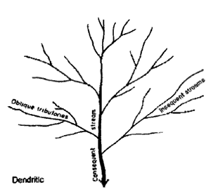
- Originally when rivers flow in the direction of the slope or as a consequence of the slope, they are called the consequent streams.
- As soon as such a river is joined by its tributary, it is called the subsequent stream.
- The subsequent stream is controlled by the underlying rock structure as it flows on weak strata lying near the master stream on its either side.
- If rocks are composed of homogeneous beds the rivers flowing over them do not have to adjust to differences in rocks. Such rivers are called the insequent rivers.
- All these river systems produce four common drainage patterns: dendritic, parallel, trellis and radial.
- The dendritic pattern is the pattern of insequent streams and is tree-like.
- The word Dendron means ‘tree’ in Greek language.
- A parallel pattern develops on steep slopes with master and its tributaries flowing almost parallel to each other for a considerable distance before meeting.
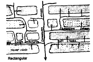
- A trellis pattern develops on a folded structure consisting of resistant anticlinal ridges separated by synclinal valleys.
- There are long straight river valleys with their tributaries joining almost at right angles, making it look like a rectangular arrangement known as trellis pattern.
- The radial pattern consists of drainage lines radiating from a central part in all direction as on a dome.
- An internal drainage is met within deserts where streams merge into the encroaching sands and fail to have their exist into a sea or a lake basin.
- An antecedent drainage is observed in mountains where a continuous down cutting has enabled the rivers to make their way through the mountain ranges rising subsequently along their way.
Delta
- The depositional feature of almost triangular shape at the mouth of a river debouching either in lake or a sea is called delta.
- The word ‘delta’ derived from Greek letter, was first used by Greek historian Herodotous for the triangular depositional feature at the mouth of the Nile river.
- An average delta consists of three beds of sediments e.g. (i) topset beds, (ii) foreset beds and (iii) bottom set beds.
| World Waterfalls | ||
| Name of the Falls | Height in meters | Location |
| Angel Falls | 979.00 | Venezuela |
| Browne Falls | 837.00 | New Zealand |
| Yosemite Falls | 739.00 | California (USA) |
| Southerland Falls | 579.34 | New Zealand |
| Roraima Falls | 457.20 | British Guiana |
| Kalambo Falls | 426.72 | South Africa |
| Gersoppa (Jog) Falls | 253.00 | Sharavati (Karnataka, India) |
| Multnomah Falls | 250.85 | Oregon (USA) |
| Bridalveil Falls | 188.97 | Yosemite, California (USA) |
Conditions for Delta Formation
- Suitable place in the form of shallow sea and lake shores.
- Long courses of the rivers (i.e. long rivers so that they bring enough amounts of sediments).
- Medium size of sediments.
- Relatively calm or sheltered sea at the mouths of the rivers.
- Large amount of sediment supply.
- Accelerated rate of erosion in the catchment area of the concerned river.
- Almost stable condition of sea coast and oceanic bottom.
Classification of Delta
- If the river is overloaded with sediments and the river water is heavier than the sea water, an elongated submarine delta is formed.
- A lobate or fan-shaped delta is formed if the river water is as dense as the seawater.
- A bird-boot delta is formed when the river water is lighter than sea water.
- Arcuate delta- Nile, Ganga, Rhine, Niger, Irrawati, Volga, Indus, Danub, Meekong, Po, Rhone, etc make such delta.
- Bird-food delta- Mississippi and Omo River make such delta.
- Estuarine delta- Narmada, Tapi, Amazon, Mackenzie, Vistuala, Elb, Seine, Hudson etc. makes such delta.
- Cuspatge delta- Ebro river makes such delta .
Ground Water
- There are about 1360 million km3 of water in the world of which 1322 million km3 are in the oceans.
| World Waterfalls | |
| Name of the Falls | Height in meters |
| Purwar or Tons Falls | 70 |
| Chachi Falls | 127 |
| Kevti Falls | 98 |
| Odda Falls | 145 |
| Devadari Falls | 58 |
| Suara Falls | 120 |
| Durgawati Falls | 80 |
| Okharean Kund Falls | 90 |
| Dhuan Kund Falls | 30 |
-
Of the remaining 4 million km3, 76.8 per cent is locked up in ice caps and glaciers, 22.6 per cent is in ground water (water below the surface), 0.56 per cent is in surface water (streams, rivers and lakes), and only 0.04 per cent is in the atmosphere in the form of water vapour.
- The transfer of water from hydrosphere to atmosphere and back again to hydrosphere is called the hydrological cycle.
Estuaries
- Fresh water from land enters the ocean through rivers, streams and ground water.
- The embayment’s where fresh water from the land meets salt water from the ocean are called estuaries.
- The most commercially important and heavily populated estuaries are the mouths of major rivers.
- It is important to note that of all the water in the world, only 0.001 per cent is in the atmosphere and that only 0.016 per cent is in surface water.
- Water which passes through the soil and enters the underlying rocks is called groundwater.
- The zone of permanent saturation where the pore spaces in a rock are always filled with water. The upper surface of this layer is called the water-table.
- The zone of intermittent saturation where the pore spaces in a rock contain water only after heavy rain.
- The zone of non-saturation where the pore spaces may contain some water yet they are never saturated- they just allow the water to pass through them.
- A part of the rainfall that falls down on the land surface seeps below the surface through the soil layers, pore spaces, joints and fissures in the rocks.
- The quantity of seepage depends on the nature of rocks and soils.
- Seepage of water through soils and rocks produces a zone of saturation below the surface, the upper limit of which is called the water table.
- Underground water is being used not only for domestic needs but also for irrigation and industries.
-
A worrying trend in the major cities of our country is the excessive use of groundwater for4 domestic and industrial consumption and for urban water supply, resulting in the progressive lowering of the water table and depletion of underground storage.
-
Groundwater acts as a buffer during times of crsis. We are depleting groundwater resources through excessive pumping; adding sewage, industrial and household wastes, chemical pesticides and insecticides, thus poisoning and polluting the resources too.
- Depletion of underground water, in many cases, has resulted in the subsidence of landforms, further leading to compression of the aquifers.
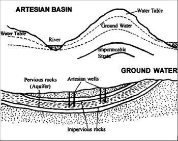
Artesian Wells
- It is special type of well, which owing to the nature of its formation is quite distinctive.
- Here, rock layers are down-folded into a basin shape so that permeable strata may be sandwiched between impermeable layers.
- The permeable rocks only come to the surface at the edges of the basin.
-
The impermeable layer below prevents the water from passing downwards while the impermeable layer on top prevents any possibility of water escaping upwards. Such a structural basin is called an aquifer.
-
Water is thus trapped in the aquifer under great pressure and when a well is bored, the pressure of water all around the basin is sufficient to force the water up the bore-hole so that it gushes onto the surface like a fountain.
- Artesian wells are most valuable to man when they can be used in desert regions like in parts of the Sahara and in Australia.
-
Earth’s magnetic poles to not coincide exactly with the geographic poles. The north magnetic pole is located on Prince of Wales Island in Canada while the south magnetic pole is located near Antarctic in the Indian Ocean south of Australia.
- When travelers contemplating a trip to Australia consult brochures and other tourist literature, they are bound to see a photograph or read a description of Ayers rock. This well known attraction is a massive feature that rises steeply from the surrounding plain. Located southwest of Alice Springs in the dry.

Endogenetic Forces: The forces coming from within the earth are called endegenetic forces which cause two types of movements in the earth viz. (i) Horizontal movements and (ii) Vertical movements.
Exogenetic Forces: The exogenetic forces or processes, also called as denudational processes, or destructional forces or porcesses are originated from the atomosphere. They are also known as plantation processes. Denudation includes both weathering and erosion.
centre of the continent, Ayers rock is a spectacular example of a feature known as an inselberg, meaning “island mountain”. However, it is a special type of inselberg that consists of a very resistant rockmass exhibiting a rounded or domed form. Such masses are termed bornhardts (born hard) because they are resistant to weathering forces.
Earthlife
-
Earth Day. April 22 is a day dedicated not just to recognize the beauty and riches of the Earth, but also to make the Earth a healthier and safer place to live. Speeches, teach-ins, sit-ins, parades and demonstrations on the occasion of the Earth Day have brought awareness about the dangers of overpopulation, energy waste, and other issues of vital concern. Earth Day was first observed on April 22, 1970 with the message “Give Earth a Chance” and propaganda to preserve the purity of the air, water and living environment.
-
Mineral Types. Although as many as 103 chemical elements are known in nature, only eight make up more than 98 per cent of the earth’s crust by weight. Moreover, the two most common elements in the crust, silicon and oxygen, constitute nearly 75 per cent of it. A useful mnemonic to remember the most abundant elements in the crust is mosaic (Oxygen, Silicon, Aluminum. Iron, Calcium).
-
Granite is the best known of all igneous rocks. This is partly because of its natural beauty, which is enhanced when it is polished, and partly because of its abundance. Slabs of polished granite are commonly used for tombstones and monuments and as building stones.
-
Gemstones, Certain mineral specimens, when cut and polished, possess beauty of such quality that they can command a price that makes the process of producing the gem profitable, Gemstones can be divided into two categories: precious and semiprecious. A precious gemhas beauty, durability, size and rarity, whereas a semi-precious gem generally has only or two of these qualities. Gems that have traditionally enjoyed the highest esteem are diamonds, rubies, sapphires, emeralds and some varieties of opal.
-
Marble is a coarse and crystalline metamorphic rock. Pure marble is white and because of its colour and relative softness, it is a popular building stone. Often the limestone from which marble forms contains impurities that colour the marble. Thus, marble can be pink, gray, green or even black. White marble is particularly prized as a stone from which to carve monuments and statues. The majestic Taj Mahal and the famous statue of David built by Michelangelo will vouch for it!
-
Krakatoa. The most recent major gigantic volcanic eruption was in 1883, when Indonesia’s Krakatoa volcano blew up with a roar heard even in Australia, 3000 km away! The blast had a force estimated at 100 million tones of dynamite. It rained pyroclastics over a huge area and propelled volcanic dust through the troposphere and stratosphere to an altitude of 80 km. For years following Krakatoa’s eruptive explosion, this dust enveloped the Earth, affecting solar radiation and colouring sunsets brilliant red. Krakatoa was an uninhabited forested island located between Java and Sumatra. Although no one was killed by its explosion, great water waves calledtsunamis were generated that dealt death and destruction.
-
Tsunami. The Japanese word for a great sea wave, tsunami, has come into general use to identify a seismic sea wave. When an earthquake’s epicenter is located on the ocean floor or near a coastline, itsshock will generate one or more waves on the water. These waves radiate outward from the point of origin. Some of these waves may reach up to a height of even 7.8 metres!
-
Grand Canyon: An ancient corridor. The Colorado River and its tributaries have cut deep gorges with wall-like sides called canyons in the soft rocks of the Colorado plateau. The Grand Canyon of Colorado is the largest of its kind and is famous for its stark natural beauty. This awesome canyon is continuously changing and growing. Though the harshlandscape appears dead and barren to the untrained eye, it is well endowed with plants and wildlife. Today, the Grand Canyon is regarded as one of the most astounding vistas in North America and like former US President Theodore Roosevelt, many consider it ‘theone great sight which every American should see’.
-
Surtsey: An island born of fire, in the early 1960s, a series of volcanic explosions fromdeep within the Earth’s core culminated in the creation of a barren crest of rock that jutted from the Atlantic Ocean, south of Iceland. The Icelandic government named it. Surtsey, inhonour of Surtur, the god of fire in Norse mythology. When viewed from above, Surtsey has been likened to the skull of a giant rodent, with craters for eye sockets and a long snout pointing northwards to Iceland. Since 1967, when eruptions ceased, Surtsey has become a laboratory where scientists have a unique opportunity to study exactly howlife takes hold in a new environment.
-
Great Wall of China. Both a barrier and a gateway to the wealth and enigma of the Chinese Empire, the Great Wall of China is a man-made work on such a gigantic scale that it has been called the Eighth Wonder of the World. More superlatives have been heapedupon the marvel than any other structure in the world. The wall stretches for some 6500 km across China, following a twisting, curving path that has been likened to the body of a dragon. The origin of the wall date back to at least the fifth century BC. It was once said to be the only man, made structure visible from the surface of the moon and, although this has proven not to be true, the wall holds a place in the record books as the largest building project ever undertaken.
Of Things Earthen
- Shape of Earth can be best described as ............................................................................. Geoid
- Earth’s rotational velocity at the equatory is ........................................................... 1690 km/hr
- A solar day is greater than a sidereal day by ............................................................... 4 minutes
- Point in the orbit of Moon when it’s farthest from Earth .................................................. Apogee
- Each degree of latitude equals ....................................................................................... ~ 111 km
- A person crossing International Date Line from East to West ................................. loses on day
- The sun is vertically overhead at the quator on ................................March 21 (spring equinox)
- Prime cause behind Earthquakes ......................................................... Dislocation along faults
- Elements constituting Earth’s crust ........................................... 0(475), Si(28%), Al(8%), Fe 5%) in terms of decreasing abundance
- Mumbai is 18,550 norht of equator. Distancewise it equals ...................................... ~ 2059 km
- Point on Earth’s surface vertically above the seismic focus ........................................ Epicentre
- Circum-Pacific belt is called Ring of Fire because .............................................. > 80% of active volcanoes are concentrated here
- Lighthouse of the Mediterranean ........................................................................... Mt. Stromboli
- Earth’s interior has a layered structure because of ............................... Density differentiation
- The intensity of earthquake waves is recorded by ................................................. Seismograph
Of Things Earthen
- Continental Drift Theory was given by ................................................................ Alfred Wegener
- Meridian accepted as the Indian Standard Time ................................................ 82½0E, passing through Allahabad Standard Time.
- Mohorovicic discontinuity separates ............................................................... Crust and Mantle
- Gigantic seismic sea-waves are called ........................................................................ Tsunamis
- Theory that considers Earth’s lithosphere as fractured along several faults ... Plate Tectonics
- Seismic waves transverse in nature which do not pass through molten outer core .. ‘S’ waves
- Gutenberg discountinuity separates ................................................................. Mantle and Core
- Theory that explains Earthquakes ......................................................... Elastic Rebound Theory
- Layer beneath the lithosphere capable of flowing under stress ......................... Asthenosphere
- IST is ahead of GMT by ................................................................................................. 5 ½ hours
- The only active volcano in India .............................. Barren Island, Andaman & Nicobar Island
- Seismic waves that cause maximum destruction ............................................... ‘L’ (long) waves
- The antipodal point of 100 N 1250 E is .......................................................................... 100S0550W
- The equatorial bulge of Earth is due to ............................... Centrifugal force of Earth’s rotation
Click Here to Download full Chapter
Click Here for Lithosphere MCQ
© UPSCPORTAL.COM
