(IGP) IAS Pre: GS - Geography - Indian Geography Physical: India Physical (Part -1)
Indian Geography Physical
India Physical (Part -1)
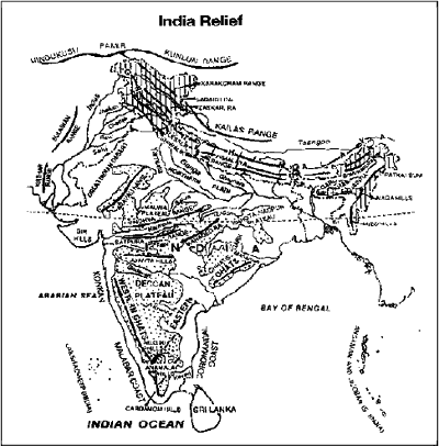
INTRODUCTION
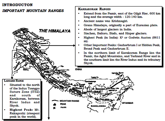
IMPORTANT MOUNTAIN RANGES
1. Great Himalaya or Himadari
- Northern most part of the Himalayan Range is the world’s highest part with an average altitude of 6100 m above sea level.
-
Include the world’s highest peak, Mt. Everest (8,848 m) and other high peaks-Makalu (8,481 m), Mansalu (8,156 m), Annapurna (8,,078 m) and also the Indian peak Manghenjunga (8,598 m) and Nanga Parbat (8,126 m).
- Includes some famous passes—Burzil and Zozi La in Kashmir, Shipki La and Bara Lapcha La in Himachal Pradesh, Thaga La, Niti Pass, and Lipu Lekh in U.P., Jelep La and Nathu La in Sikkim.
ZASKAR RANGE
- Situated on the western part of the Greater Himlaya and to the south of Trans Himalaya.
Nanaga Parbat (8,126 m)
- Forms the north-west part of Zaskar Range but geographically confined to Kashmir-Himachal Pradesh- Garhwal region.
- Second highest peak of the Himalayan Range in India.
Dhaulagiri (8,172 m)
- Eastern continuation of Nanga Parbat and is located in Nepal.
2. Lesser Himalaya or Himachal
- Lying to the north of Siwalik Range they are separated from the Siwalik Range by Duns— Dehradun, Kothridun and Patlidun.
(I) PIR PANJAL RANGE
- Located in Kashmir—Punjab and extends from the Jhelum River to the upper Beas River for over 300 km.
- Separated from the Zaskar Range by the valley of Kashmir.
(II) DHAULADHAR
- Southern most range of the Lessers Himalaya.
- Rarely attains elevations higher than 4,000 m.
- Continue eastward into Mahabharat Range.
3. Siwalik Range
- Estends from Jammu & Kashmir (150 km wide) to Arunchal Pradesh (8-15 km) over 2400 km.
- Also known as Sub-Himalaya or Outer Himalaya.
- Northern limit—Main Boundary Thrust which separates Outer Himalaya fromthe Lesser Himalaya. Its southern limit is Indo Gangetic Plain.
- Youngest part of mountain chain, stretching from the Brahmputra to the Indus.
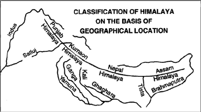
CLASSIFICATION OF HIMALAYA ON THE BASIS OF GEOGRAPHICAL LOCATION
| NAME | LOCATION | DISTANCE |
| Punjab Himalaya | Between Indus and Satluj | 560 km |
| Kumaon Himalaya | Between Satluj and Kali | 320 km |
| Nepal Himalaya | Between Kali and Tista | 800 km |
| Assam Himalaya | Between Tista and Dihang | 720 km |
THE PURVANCHAL
(The North Eastern Highland)
- The Himalaya range after crossing the Dihang gorge in the east, bends southwards, forming a series of hills in north south trend.
- They are divided into six physiographic region-Purvu-NEFA (Mishmi hills, Patkai Bum), Nagaland, the Manipur Hills, North Cachar Hills, Mizo Hills and the Tripura Hills.

PURVU NEPA
(i) Mishmi Hills
- The highest range of Purvanchal Hills which is situated in the north-eastern part of Arunachal Pradesh.
(ii) Patkai Bum
- A synclinal range extending north-south in Arunchal Pradesh and Nagaland.
NAGA RANGES
- Forms the Watershed between Nagaland and Myanmar.
MANIPUR HILLS
- Characterised by ridge and valley type of topography.
- Loktak lake (centripetal drainage) is situated in this hill.
NORTH CACHAR HILLS
- Larger portion of hilly belt lying between Meghalaya and the North eastern ranges.
MIZO HILLS
- Previously known as Lushai Hills
- Characterised by cuesta type of topography.
TRIPURA HILLS
- Characterised by ridge and valley topography.
The Northern Plains of India |
|
| East-west east 2,400 km (3,200 km if the Indus plains are included Average width: 150-300 km.) |
|
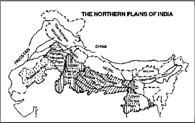
SUBDIVISION OF GREAT PLAINS
| THE RAJASTHAN PLAIN Extent : 650 km long. Average width : 250-300 km wide |
|
| THE PUNJAB HARYANA PLAINS
Extent : 640 km from north- west to southeast and 300 km in east west direction. |
|
| THE GANGA PLAINS |
|
| THE BRAHMPUTRA PLAIN |
|
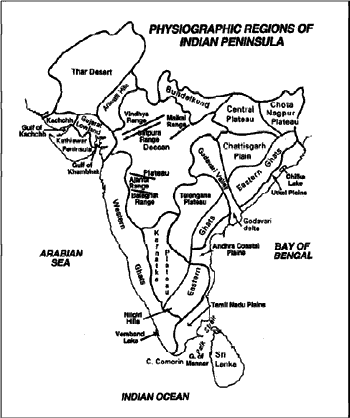
Peninsular Mountains
| THE ARAVALLI RANGE
Total length : 700 km. |
|
| VINDHYAN RANGE |
|
| SATPURA RANGE
Highest peak : Dhupgarh (1,350 m) near Pachmarhi. |
|
| MAIKAL RANGE |
|
| AJANTA RANGE, BALAGHAT RANGE, AND HARISH CHANDRA RANGE |
|
| NILGIRI HILLS |
|
| ANNAIMALAI HILLS |
|
| CARDAMOM HILLS |
|
| RAJMAHAL HILLS |
|
| SAHYADRIS (WESTERN GHATS)
Total length : about 1600 km. |
|
| EASTERN GHATS |
|
The Indian Plateau
BUNDELKHAND BHANDER, BAGHEL AND MALWA PLATEAU
- These highlands are situated to the north of Narmada rift vallye.
- Bundelkhand Plateau is a part of central highlands and is composed of granite and gneisses.
- Malwa plateau is an example of dissected lava plateau, which is covered with black soil.
MEGHALAYA PLATEAU
- It comprises of Garo, Khasi and Jaintia Hills.
- Originally a part of Peninsular plateau.
- Garo-Rajmahal Gap separates it from the main block of peninsular plateau.
CHOTANAGPUR PLATEAU
Highest Peak - Parasnath (1,366 m) in the Hazaribagh Plateau.
- Situated in the north eastern part of Indian Plateau includes the region of Jharkhand, adjoining Chhattisgarh and West Bengal.
- It consists of the Ranchi Plateau in the south, the Hazaribagh Plateau in the north, and the Rajmahal Hills in the northwest.
- Described as the “Ruhr of India”
- Pat lands are one of the chief characteristics of Chotanagpur Plateau.
- Very rich in mineral resources.
DECCAN PLATEAU
- South of the Satpura Range in the peninsula is called the Deccan Plateau.
(1) The Deccan Lava Plateau Region
- Northwestern part of Deccan Plateau is the region of basaltic lava.
- It includes the Western Ghats north of 160 north latitude, plateau of Maharashtra (except the east of Nagpur) and the adjoining parts of Madhya Pradesh, Karnataka and Andhra Pradesh.
(2) Telengana Plateau
- Part of the Deccan Plateau, comprises of the interior region of Andhra Pradesh.
- North of Krishna River is the plateau of Telangana.
- South of the Krishna River, lying in the Rayalseema plateau region.
(3) The Karnataka Plateau
- Situated to the south of Deccan Lava Region.
- Malnad and Maidan are two physiographic regions of Karnataka Plateau.
(i) Malnad
- Hilly and dissected plateau region about 35 km wide lying close to the Western Ghats. The highest hills is the Bababudan group.
(ii) Maidan
- Situated in the eastern part of Malnad, relatively large rolling plains with low granitic hills.
THE WEST COASTAL PLAIN
- Runs from Rann of Kachchh to Kanniyakumari and are confined to a narrow belt about 10-15 km wide.
KATHIAWAR COAST
- Extends from Rann of Kuchchh to Daman in the south.
KONKAN COAST (Total length : 500 km)
- The West Coastal Plain between Daman in the north and Goa in the south in example of coast of submergence due to vertical movements, and is consequently dissected.
Malabar Coast
- Extends from Goa in the north to Kanniyakumari in the south is a coastline of emergence.
- Southern coastal region receives more rainfall during summer monsoon season.
THE EAST COASTAL PLAIN
- Extends from the deltaic plains of the Ganga in the north to Kanniyakumari in the south for 1100 km with an average width of 100 to 130km.
(I) UTKAL COAST
- Extends for about 400 km from a little north of Subarnarekha river of the Ganga of the Mahanadi delta.
(II) ANDHRA GOASTAL PLAINS
- Extends from the southern limit of Utkal plains to Pulicat lake (Andhra Pradesh).
- It has large deltas of the Krishna and the Godavari rivers.
(III) TAMIL NADU PLAINS
- Extends about 675 km, from the north of Chennai to Kanniyakumari in the south.
- It has the deltaic plains of Cauvery and is popularly called, the Granary of South India.
Important Gulfs
| NAME | SEPARATES | LOCATION | INFORMATION |
| Gulf of Kachchh | Kachchh and Kathiawar Peninsula | West of Gujarat | Region with highest potential of tidal energy generation. |
| Gulf of Cambay | Kathiawar Peninsula and Gujarat | Gujarat | Tapi, Narmada, Mahi and Sabarmati river drain into the Gulf. |
| Gulf of Mannar | Sri Lanka and Southern India | South east of | Asia’s first marine biosphere reserve. |
Important Lagoons and Lakes
| NAME | STATE | INFORMATION |
| Kayals | Kerala | Popularly called backwaters in Kerala, on the Malabar coast.
A chain of lakes which are connected with each other by canals. (Peaty soils of backwaters are called Kari in Kerala). |
| Vembnad Lake (Largest Kayal) | Kerala | Large sized backwater of Kerala, have fertile alluvial islands. It is 75 km long and 5-10 km wide enclosed by a spit. |
| Chilka Lake
Maximum length - 64 km Maximum breath - 20 km |
Orissa | Situated to the south west of the Mahanadi Delta.
Enclosed by the sand pit, has an opening which permits sea-connection. Largest brackish water lake in Asia. |
Fresh Water Lakes |
||
| Wullar Lake | Jammu and Kashmir | Largest fresh water lake of India. |
| Kolleru Lake
60 km long and 60 km in the widest part. |
Andhra Pradesh | A part of the southern border of Andhra Pradesh.
Lagoon formed due to enclosure by sand spit now called Sriharikota islands. |
| Jaisamand Lake | Rajasthan | Largest fresh water lake of Rajasthan. |
| Nakki Lake | Rajasthan | A small natural lake near Mt. Abu surrounded by hills, important as tourist place. |
| Loktak Lake | Manipur | Site of hydroelectricity power generation. An example of centripetal drainage. |
| Saline Water Lakes | ||
| Sambhar Lake | Rajasthan | Largest Lake of Rajasthan lies on the border of Jaipur and Nagaur District.
Sodiumchloride (common salt) and sodiumsulphate are produced fainly by the Hindustan Salt Ltd. |
| Deedwana Lake | Rajasthan | Situated near Deedwana Town of Nagaur District. |
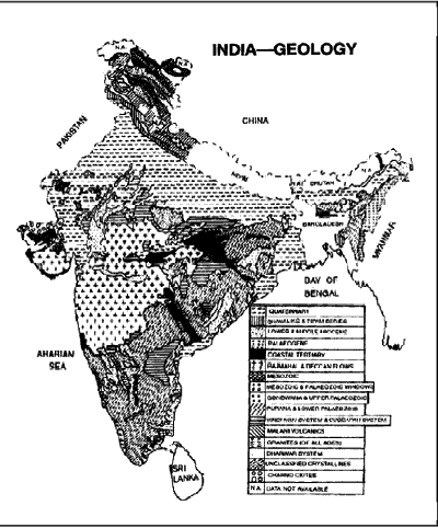
INDIA—THEMATIC MAPS
INDIA GEOLOGY
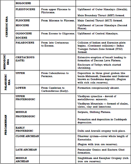
Geology Time Scale

Click Here to Download full Chapter
Click Here for India Physical MCQ
© UPSCPORTAL.COM
